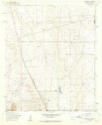
1955 Map of Newman SW
USGS Topo · Published 1962About this map
The Fort Bliss Military Reservation dominates this desert landscape along the border of New Mexico and Texas, capturing a high-altitude arid environment defined by isolated water sources and military land use during the mid-1950s. The southern portion of the map transitions into the jagged peaks of the Franklin Mountains, while the basin floor is dotted with remote landmarks such as Quake Lake and a small Cem near the New Mexico-Texas state line. The reliance on subterranean water is evident through numerous named wells, including Jessie Well, Blythe Well, and the descriptively named Wiggly Well. Traces of past activity appear as Ruins and a lone Tower, marking the intersection of military operations and the sparse ranching infrastructure typical of Dona Ana County before modern expansion.
Find a feature on this map
14 named features on this map. Tap any name to fly to it.
Don’t see what you’re looking for? This feature index may not catch every label — zoom into the map to look around manually.
Map Details
Editions of this 1955 Newman SW Map
This is the sole edition of this map. No revisions or reprints were ever made.
Other maps of this area

1891 · Las Cruces
USGS Topo · 1:125,000

1893 · Las Cruces
USGS Topo · 1:125,000

1896 · El Paso
USGS Topo · 1:125,000

1908 · El Paso
USGS Topo · 1:125,000

1917 · Canutillo
USGS Topo · 1:62,500

1919 · Canutillo
USGS Topo · 1:62,500

1940 · Newman
USGS Topo · 1:62,500

1942 · Fort Bliss
USGS Topo · 1:62,500

1943 · La Mesa
USGS Topo · 1:62,500

1943 · Newman
USGS Topo · 1:62,500