
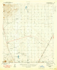
1943 Map of Newman
USGS Topo · Published 1943About this map
Isolated ranching outposts and remote desert infrastructure define this 1940s landscape along the New Mexico Texas border. The map illustrates a high-desert environment where water sources like Jessie Well, Wessly Well, and Old Coe Lake dictated the placement of family holdings. These operations, including the Trueblood Ranch, Duderstadt Ranch, and Manning Ranch, are scattered across the arid plains between the Franklin Mountains and the Organ Mts.
Find a feature on this map
32 named features on this map. Tap any name to fly to it.
Don’t see what you’re looking for? This feature index may not catch every label — zoom into the map to look around manually.
Map Details
Editions of this 1943 Newman Map
2 editions found
Other maps of this area

1891 · Las Cruces
USGS Topo · 1:125,000

1893 · Las Cruces
USGS Topo · 1:125,000

1896 · El Paso
USGS Topo · 1:125,000

1908 · El Paso
USGS Topo · 1:125,000

1917 · Canutillo
USGS Topo · 1:62,500

1919 · Canutillo
USGS Topo · 1:62,500

1939 · Heuco Tanks
USGS Topo · 1:62,500

1940 · Heuco Tanks
USGS Topo · 1:62,500

1940 · Orogrande
USGS Topo · 1:62,500

1940 · Newman
USGS Topo · 1:62,500