
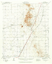
1940 Map of Newman
USGS Topo · Published 1965About this map
Ranching life and early 20th-century transportation networks define this arid landscape along the border of New Mexico and Texas. Surveyed in 1940, the territory is anchored by the Southern Pacific railroad, which cuts diagonally across the basin floor toward the settlement of Newman and the stop at Hueco. The map reveals a highly decentralized pattern of life, where water sources like Old Coe Lake, Wessly Well, and Jessie Well dictated the placement of family operations including the Henry Ranch, Blythe Ranch, and Trueblood Ranch.
Find a feature on this map
31 named features on this map. Tap any name to fly to it.
Don’t see what you’re looking for? This feature index may not catch every label — zoom into the map to look around manually.
Map Details
Editions of this 1940 Newman Map
This is the sole edition of this map. No revisions or reprints were ever made.
Other maps of this area

1891 · Las Cruces
USGS Topo · 1:125,000

1893 · Las Cruces
USGS Topo · 1:125,000

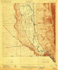
1896 · El Paso
USGS Topo · 1:125,000

1908 · El Paso
USGS Topo · 1:125,000
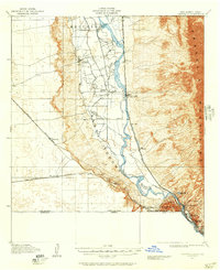
1917 · Canutillo
USGS Topo · 1:62,500
1919 · Canutillo
USGS Topo · 1:62,500

1939 · Heuco Tanks
USGS Topo · 1:62,500

1940 · Heuco Tanks
USGS Topo · 1:62,500
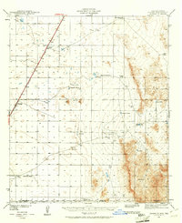
1940 · Orogrande
USGS Topo · 1:62,500
1941 · Desert
USGS Topo · 1:62,500