
1941 Map of Desert
USGS Topo · Published 1961About this map
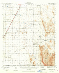
The Southern Pacific railroad slices diagonally across this high-desert basin, providing a vital transportation corridor through the arid Tularosa Valley just north of the state line. In the years before World War II, this landscape was defined by its water sources, where remote outposts like McCracken Ranch and Davis Ranch relied on an extensive network of artificial and natural catchments such as Chaparral Tank and Alvarado Tank No. 2. The small railroad sidings at Desert and Alvarado serve as primary anchors for the region's cattle and rail operations.
Find a feature on this map
20 named features on this map. Tap any name to fly to it.
Don’t see what you’re looking for? This feature index may not catch every label — zoom into the map to look around manually.
Map Details
Editions of this 1941 Desert Map
2 editions found
Other maps of this area

1896 · El Paso
USGS Topo · 1:125,000

1903 · Cerro Alto
USGS Topo · 1:125,000

1908 · El Paso
USGS Topo · 1:125,000

1939 · Heuco Tanks
USGS Topo · 1:62,500

1940 · Heuco Tanks
USGS Topo · 1:62,500

1940 · Bassett Lake
USGS Topo · 1:62,500

1940 · Orogrande
USGS Topo · 1:62,500

1940 · Newman
USGS Topo · 1:62,500

1941 · Heuco Mountains
USGS Topo · 1:62,500

1942 · Fort Bliss
USGS Topo · 1:62,500