1940s Maps of Radium Springs, New Mexico
Explore 3 historic maps of Radium Springs from the 1940s. These maps offer a rare glimpse into what life looked like during the 1940s — showing old roads, neighborhoods, homes, and landmarks that have changed or disappeared over time.
Whether you're researching your family's past, planning a metal detecting trip, or studying how Radium Springs's landscape evolved across the 1940s, these high-resolution maps are a powerful tool for exploring the history of this region.
- Focus on a specific era: All maps on this page are from the 1940s, giving you a focused view of this time period.
- See what’s changed: Compare century-old streets, trails, and buildings to today's modern landscape using overlays and satellite layers.
- Research with precision: Use these maps for genealogy, historical research, land use analysis, or educational projects.
- View, download, or print: Maps are fully viewable online in high resolution, and can be downloaded or printed for your own records.
Start exploring Radium Springs's history through authentic maps from the 1940s. This is your window into the past.
Radium Springs, NM maps
(3)- 1941 Map of Las Cruces, 1958 Print
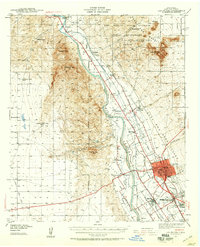 1941 Las Cruces1958 Print · USGSThe Rio Grande valley comes alive in the early 1940s, showing a landscape defined by irrigation and early college life. Trace family roots at Mesilla, the Ruins of Fort Selden, or the grounds of New Mexico State College.2 unique versions available
 - 1943 Map of Las Cruces
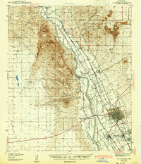 1943 Las Cruces1943 Print · USGSThe Mesilla Valley in the early 1940s reveals a complex network of irrigation canals and historic river settlements. Genealogists and researchers can trace the early footprints of New Mexico State College, the Ruins of Fort Selden, and local institutions like Loretto Academy.
 - 1948 Map of San Diego Mountain, 1954 Print
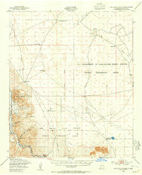 1948 San Diego Mountain1954 Print · USGSIn the high desert of the late 1940s, this area north of Las Cruces was a hub for agricultural research and river-valley transit. Trace the early tracks of the Atchison Topeka and Santa Fe near Tonuco or locate family-named sites like Real Ranch and Lytten Well.2 unique versions available
End of results
Showing maps 1-3 of 3
Top cities near Radium Springs
Top neighborhoods of Radium Springs
Frequently asked questions
- What are the different types of historical maps available for Radium Springs?
- What is the oldest map of Radium Springs?
- Where can I purchase historical maps of Radium Springs for my home or office?
- Where can I download high-res historical maps of Radium Springs?
- Are there historical topographic maps available for Radium Springs?
- Is there historical aerial imagery available for Radium Springs?
- Where are historical maps of Radium Springs sourced from?