1900s (20th Century) Maps of Radium Springs, New Mexico
Explore 13 historic maps of Radium Springs from the 1900s (20th Century). These maps offer a rare glimpse into what life looked like during the 1900s — showing old roads, neighborhoods, homes, and landmarks that have changed or disappeared over time.
Whether you're researching your family's past, planning a metal detecting trip, or studying how Radium Springs's landscape evolved across the 1900s, these high-resolution maps are a powerful tool for exploring the history of this region.
- Focus on a specific era: All maps on this page are from the 1900s, giving you a focused view of this time period.
- See what’s changed: Compare century-old streets, trails, and buildings to today's modern landscape using overlays and satellite layers.
- Research with precision: Use these maps for genealogy, historical research, land use analysis, or educational projects.
- View, download, or print: Maps are fully viewable online in high resolution, and can be downloaded or printed for your own records.
Start exploring Radium Springs's history through authentic maps from the 1900s. This is your window into the past.
Radium Springs, NM maps
(13)- 1916 Map of Tonuco
 1916 Tonuco1916 Print · USGSDona Ana and Socorro counties are shown during the mid-1910s, capturing a landscape of isolated desert ranches and railroad stops. Genealogists can trace family outposts and water sources such as Flat Lake Ranch, Baird's Ranch, and Red Lake well.
 - 1932 Map of Tonuco
 1932 Tonuco1932 Print · USGSThe high desert of southern New Mexico appears here as a land of isolated ranches and railroad sidings in the early 1930s. Genealogists and historians can trace family-named outposts like Detroit Ranch and Ritch Ranch or follow the A. T. & S. F. line past Aleman.
 - 1941 Map of Las Cruces, 1958 Print
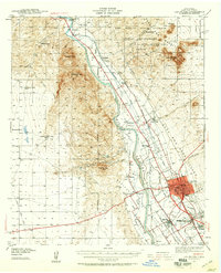 1941 Las Cruces1958 Print · USGSThe Rio Grande valley comes alive in the early 1940s, showing a landscape defined by irrigation and early college life. Trace family roots at Mesilla, the Ruins of Fort Selden, or the grounds of New Mexico State College.2 unique versions available
 - 1943 Map of Las Cruces
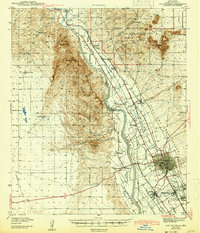 1943 Las Cruces1943 Print · USGSThe Mesilla Valley in the early 1940s reveals a complex network of irrigation canals and historic river settlements. Genealogists and researchers can trace the early footprints of New Mexico State College, the Ruins of Fort Selden, and local institutions like Loretto Academy.
 - 1948 Map of San Diego Mountain, 1954 Print
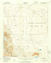 1948 San Diego Mountain1954 Print · USGSIn the high desert of the late 1940s, this area north of Las Cruces was a hub for agricultural research and river-valley transit. Trace the early tracks of the Atchison Topeka and Santa Fe near Tonuco or locate family-named sites like Real Ranch and Lytten Well.2 unique versions available
 - 1955 Map of Las Cruces, 1963 Print
 1955 Las Cruces1963 Print · USGSSouthern New Mexico comes into focus during the mid-fifties, showing the growth of Las Cruces alongside major military and scientific installations. Genealogists and historians can trace the Southern Pacific tracks through small rail towns like Cambray and Afton, or locate family sites near Hatch and Deming.3 unique versions available
 - 1958 Map of Las Cruces
 1958 Las Cruces1958 Print · USGSSouthern New Mexico in the late fifties was a landscape of rapid scientific and military growth centered on the Rio Grande. Local historians can trace the development of Las Cruces, the campus of New Mexico A and M College, and remote rail sidings like Aden Siding.
 - 1978 Map of Leasburg
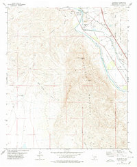 1978 Leasburg1978 Print · USGSThe Mesilla Valley north of Las Cruces appears in the late seventies as a crossroads of frontier history and modern irrigation. Historians can trace the grounds of Fort Selden or follow the Atchison Topeka and Santa Fe rail line past Radium Springs.2 unique versions available
 - 1982 Map of Selden Canyon
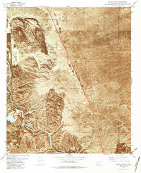 1982 Selden Canyon1982 Print · USGSThe southern Rincon Valley comes alive in the early eighties as the rail line follows the river's bend through the desert. Local researchers can trace the rail corridor of the Atchison Topeka and Santa Fe or locate isolated landmarks like Lytton Well and the community of Radium Springs.2 unique versions available
 - 1982 Map of White Sands
 1982 White Sands1982 Print · USGSNew Mexico's high desert reveals its complex military and scientific heritage during the early eighties, from the gypsum dunes to the missile ranges. Researchers can trace the massive boundaries of White Sands National Monument and locate the White Sands Test Facility (NASA) among the rugged San Andres Mountains.
 - 1982 Map of Las Cruces
 1982 Las Cruces1982 Print · USGSThe Rio Grande valley and the Organ Mountains define this 1980s portrait of southern New Mexico's ranching and military landscape. Trace historic land divisions like the Brazito Grant alongside landmarks such as Santo Tomas and the Silver King Mine.
 - 1996 Map of Leasburg, 2002 Print
 1996 Leasburg2002 Print · USGSThe Mesilla Valley north of Las Cruces appears here in the mid-1990s as a landscape of historic frontier outposts and complex desert irrigation. Researchers can trace the Rio Grande’s course past the Fort Selden State Monument, Leasburg Dam, and the winding Leasburg Canal.
 - 1996 Map of Selden Canyon, 2002 Print
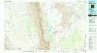
 1996 Selden Canyon2002 Print · USGSThe Mesilla Valley north of Las Cruces appears here in the late twentieth century, where the river meets the high desert. Researchers can trace the Rio Grande through Selden Canyon and locate points like the NMSU Animal Science Ranch and Radium Springs.
End of results
Showing maps 1-13 of 13
Top cities near Radium Springs
Top neighborhoods of Radium Springs
Frequently asked questions
- What are the different types of historical maps available for Radium Springs?
- What is the oldest map of Radium Springs?
- Where can I purchase historical maps of Radium Springs for my home or office?
- Where can I download high-res historical maps of Radium Springs?
- Are there historical topographic maps available for Radium Springs?
- Is there historical aerial imagery available for Radium Springs?
- Where are historical maps of Radium Springs sourced from?