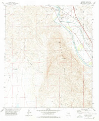
1978 Map of Leasburg
USGS Topo · Published 1978This historical map portrays the area of Leasburg in 1978, primarily covering Doña Ana County. Featuring a scale of 1:24000, this map provides a highly detailed snapshot of the terrain, roads, buildings, counties, and historical landmarks in the Leasburg region at the time. Published in 1978, it is one of 2 known editions of this map due to revisions or reprints.
Find a feature on this map
30 named features on this map. Tap any name to fly to it.
Don’t see what you’re looking for? This feature index may not catch every label — zoom into the map to look around manually.
Map Details
Editions of this 1978 Leasburg Map
2 editions found
Historical Maps of Radium Springs Through Time
109 maps found

1916 Tonuco
Doña Ana County, NM

1917 Mt. Riley
Doña Ana County, NM

1917 Noria
Doña Ana County, NM

1918 Mt. Riley
Doña Ana County, NM

1918 Noria
Doña Ana County, NM

1929 Mt. Riley
Doña Ana County, NM

1932 Tonuco
Doña Ana County, NM

1941 Aden
Doña Ana County, NM

1941 Organ Peak
Doña Ana County, NM

1943 Aden
Doña Ana County, NM

1943 Afton
Doña Ana County, NM

1943 Corralitos Ranch
Doña Ana County, NM

1943 Organ Peak
Doña Ana County, NM

1947 Point Of Sands 2
Doña Ana County, NM

1948 Bear Peak
Doña Ana County, NM

1948 Davies Tank
Doña Ana County, NM

1948 Kaylor Mountain
Doña Ana County, NM

1948 Lake Lucero
Doña Ana County, NM

1948 Lake Lucero SW
Doña Ana County, NM

1948 Newman NW
Doña Ana County, NM

1948 San Diego Mountain
Doña Ana County, NM

1950 Lake Lucero
Doña Ana County, NM

1950 Lake Lucero SW
Doña Ana County, NM

1951 Mt. Riley
Doña Ana County, NM

1952 Parker Lake
Doña Ana County, NM

1955 Bishop Cap
Doña Ana County, NM

1955 Davies Tank
Doña Ana County, NM

1955 Newman NW
Doña Ana County, NM

1955 Newman SW
Doña Ana County, NM

1955 Organ Peak
Doña Ana County, NM

1955 Organ Peak NW
Doña Ana County, NM

1955 Strauss
Doña Ana County, NM

1955 Tortugas Mountain
Doña Ana County, NM

1956 Parker Lake
Doña Ana County, NM

1959 Sierra Alta
Doña Ana County, NM

1959 Souse Springs
Doña Ana County, NM

1978 Afton
Doña Ana County, NM

1978 Dona Ana
Doña Ana County, NM

1978 Leasburg
Doña Ana County, NM

1978 Picacho Mountain
Doña Ana County, NM

1981 Bear Peak
Doña Ana County, NM

1981 Bennett Mountain
Doña Ana County, NM

1981 Fleck Draw
Doña Ana County, NM

1981 Gardner Peak
Doña Ana County, NM

1981 Gilmore Draw
Doña Ana County, NM

1981 Goldenburg Draw
Doña Ana County, NM

1981 Hembrillo Canyon
Doña Ana County, NM

1981 San Andres Peak
Doña Ana County, NM

1982 Heart of the Sands NW
Doña Ana County, NM

1982 Heart of the Sands SW
Doña Ana County, NM

1982 Lake Lucero
Doña Ana County, NM

1982 Selden Canyon
Doña Ana County, NM

1982 Selden Canyon NE
Doña Ana County, NM

1982 Summerford Mountain
Doña Ana County, NM

1982 Taylor Well
Doña Ana County, NM

1982 Thorn Well
Doña Ana County, NM

1985 Aden Crater
Doña Ana County, NM

1985 Aden Hills
Doña Ana County, NM

1985 Guzmans Lookout Mountain
Doña Ana County, NM

1985 Kilbourne Hole
Doña Ana County, NM

1985 Lanark
Doña Ana County, NM

1985 Magdalena Gap
Doña Ana County, NM

1985 Magdalena Peak
Doña Ana County, NM

1985 Mount Aden
Doña Ana County, NM

1985 Mount Aden SW
Doña Ana County, NM

1985 Mount Riley
Doña Ana County, NM

1985 Mount Riley SE
Doña Ana County, NM

1985 Noria
Doña Ana County, NM

1985 Potrillo
Doña Ana County, NM

1985 Potrillo Peak
Doña Ana County, NM

1985 Rough And Ready Hills
Doña Ana County, NM

1985 Sleeping Lady Hills
Doña Ana County, NM

1994 Strauss
Doña Ana County, NM

1996 Aden Crater
Doña Ana County, NM

1996 Aden Hills
Doña Ana County, NM

1996 Afton
Doña Ana County, NM

1996 Afton NW
Doña Ana County, NM

1996 Bear Peak
Doña Ana County, NM

1996 Bishop Cap
Doña Ana County, NM

1996 Black Mesa
Doña Ana County, NM

1996 Dona Ana
Doña Ana County, NM

1996 Fleck Draw
Doña Ana County, NM

1996 Gardner Peak
Doña Ana County, NM

1996 Gilmore Draw
Doña Ana County, NM

1996 Goldenburg Draw
Doña Ana County, NM

1996 Kilbourne Hole
Doña Ana County, NM

1996 Lanark
Doña Ana County, NM

1996 Leasburg
Doña Ana County, NM

1996 Little Black Mountain
Doña Ana County, NM

1996 Magdalena Peak
Doña Ana County, NM

1996 Mount Aden
Doña Ana County, NM

1996 Mount Aden SW
Doña Ana County, NM

1996 Mount Riley
Doña Ana County, NM

1996 Noria
Doña Ana County, NM

1996 Organ Peak
Doña Ana County, NM

1996 Organ Peak NW
Doña Ana County, NM

1996 Picacho Mountain
Doña Ana County, NM

1996 San Andres Peak
Doña Ana County, NM

1996 Selden Canyon
Doña Ana County, NM

1996 Selden Canyon NE
Doña Ana County, NM

1996 Sierra Alta
Doña Ana County, NM

1996 Sleeping Lady Hills
Doña Ana County, NM

1996 Souse Springs
Doña Ana County, NM

1996 Strauss
Doña Ana County, NM

1996 Summerford Mountain
Doña Ana County, NM

1996 Taylor Well
Doña Ana County, NM

1996 Thorn Well
Doña Ana County, NM

1996 Tortugas Mountain
Doña Ana County, NM

2001 Rough And Ready Hills
Doña Ana County, NM
Featured Locations
- United States
- Doña Ana County, NM
- Radium Springs, NM
- Fort Selden, Radium Springs
- Leasburg, Radium Springs