1950s Maps of Santa Teresa, New Mexico
Explore 5 historic maps of Santa Teresa from the 1950s. These maps offer a rare glimpse into what life looked like during the 1950s — showing old roads, neighborhoods, homes, and landmarks that have changed or disappeared over time.
Whether you're researching your family's past, planning a metal detecting trip, or studying how Santa Teresa's landscape evolved across the 1950s, these high-resolution maps are a powerful tool for exploring the history of this region.
- Focus on a specific era: All maps on this page are from the 1950s, giving you a focused view of this time period.
- See what’s changed: Compare century-old streets, trails, and buildings to today's modern landscape using overlays and satellite layers.
- Research with precision: Use these maps for genealogy, historical research, land use analysis, or educational projects.
- View, download, or print: Maps are fully viewable online in high resolution, and can be downloaded or printed for your own records.
Start exploring Santa Teresa's history through authentic maps from the 1950s. This is your window into the past.
Santa Teresa, NM maps
(5)- 1953 Map of El Paso
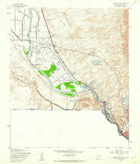
 1953 El Paso1953 Print · USGSEl Paso and the border region are shown here in the early fifties, documenting a landscape of shared river life and rising military presence. Genealogists and historians can trace rail-tied communities like Smeltertown, San Elizario, and the grounds of Fort Bliss.
 - 1955 Map of Smeltertown, 1962 Print
 1955 Smeltertown1962 Print · USGSEl Paso and the borderlands are seen here in the mid-fifties, where industry and education meet the high desert. Researchers can trace the riverfront development of Smeltertown or locate historical sites like La Guna Cem and the University of Texas Western College.5 unique versions available
 - 1955 Map of Strauss, 1962 Print
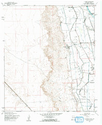
 1955 Strauss1962 Print · USGSThe borderlands of southern New Mexico meet the Texas line in the mid-1950s, centered on the vital rail traffic of the southwest. Genealogists and rail historians can trace the Southern Pacific through Strauss, find the Santa Nina Ch, and follow the Old Railroad Grade near Mastodon.
 - 1955 Map of La Union, 1962 Print
 1955 La Union1962 Print · USGSThe Mesilla Valley landscape comes alive in this mid-fifties study of the irrigated corridor south of Las Cruces. Genealogists and local historians can trace the foundations of La Union, the Refugio Colony, and rural landmarks like St Lukes Ch and Central Sch.2 unique versions available
 - 1959 Map of El Paso, 1968 Print
 1959 El Paso1968 Print · USGSEl Paso and the international borderlands come alive in this mid-century survey of the Chihuahuan Desert. Genealogists and historians can trace rail-side settlements like Columbus and Fabens, locate the sprawling Fort Bliss, and explore the geologically unique Kilbourne Hole.2 unique versions available
End of results
Showing maps 1-5 of 5
Top cities near Santa Teresa
- El Paso historical maps
- Sunland Park historical maps
- Anthony historical maps
- Anthony, NM historical maps
- Canutillo historical maps
- Anthony historical maps
See more
Top neighborhoods of Santa Teresa
Frequently asked questions
- What are the different types of historical maps available for Santa Teresa?
- What is the oldest map of Santa Teresa?
- Where can I purchase historical maps of Santa Teresa for my home or office?
- Where can I download high-res historical maps of Santa Teresa?
- Are there historical topographic maps available for Santa Teresa?
- Is there historical aerial imagery available for Santa Teresa?
- Where are historical maps of Santa Teresa sourced from?