1990s Maps of Vado, New Mexico
Explore 2 historic maps of Vado from the 1990s. These maps offer a rare glimpse into what life looked like during the 1990s — showing old roads, neighborhoods, homes, and landmarks that have changed or disappeared over time.
Whether you're researching your family's past, planning a metal detecting trip, or studying how Vado's landscape evolved across the 1990s, these high-resolution maps are a powerful tool for exploring the history of this region.
- Focus on a specific era: All maps on this page are from the 1990s, giving you a focused view of this time period.
- See what’s changed: Compare century-old streets, trails, and buildings to today's modern landscape using overlays and satellite layers.
- Research with precision: Use these maps for genealogy, historical research, land use analysis, or educational projects.
- View, download, or print: Maps are fully viewable online in high resolution, and can be downloaded or printed for your own records.
Start exploring Vado's history through authentic maps from the 1990s. This is your window into the past.
Vado, NM maps
(2)- 1996 Map of San Miguel, 2002 Print
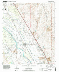 1996 San Miguel2002 Print · USGSThe Mesilla Valley in the mid-nineties shows a landscape of historic colonies and intricate irrigation systems along the Rio Grande. Researchers can trace old family footprints through settlements like Santo Tomas, locate the La Mesa Cemetery, or follow the Atchison Topeka and Santa Fe rail line.
 - 1996 Map of La Mesa, 2002 Print
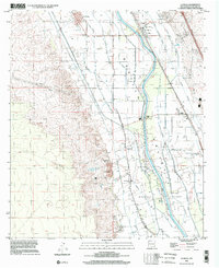 1996 La Mesa2002 Print · USGSThe Mesilla Valley in the late twentieth century is shown here as a complex grid of irrigation and agriculture along the Rio Grande. Researchers can trace the layout of the Refugio Colony and locate community landmarks like Dunbar Sch and the San Luis Cem.
End of results
Showing maps 1-2 of 2
Top cities near Vado
- El Paso historical maps
- Las Cruces historical maps
- Anthony historical maps
- Anthony, NM historical maps
- Canutillo historical maps
- Anthony historical maps
See more
Frequently asked questions
- What are the different types of historical maps available for Vado?
- What is the oldest map of Vado?
- Where can I purchase historical maps of Vado for my home or office?
- Where can I download high-res historical maps of Vado?
- Are there historical topographic maps available for Vado?
- Is there historical aerial imagery available for Vado?
- Where are historical maps of Vado sourced from?