1940s Maps of Four Wells, New Mexico
Explore 2 historic maps of Four Wells from the 1940s. These maps offer a rare glimpse into what life looked like during the 1940s — showing old roads, neighborhoods, homes, and landmarks that have changed or disappeared over time.
Whether you're researching your family's past, planning a metal detecting trip, or studying how Four Wells's landscape evolved across the 1940s, these high-resolution maps are a powerful tool for exploring the history of this region.
- Focus on a specific era: All maps on this page are from the 1940s, giving you a focused view of this time period.
- See what’s changed: Compare century-old streets, trails, and buildings to today's modern landscape using overlays and satellite layers.
- Research with precision: Use these maps for genealogy, historical research, land use analysis, or educational projects.
- View, download, or print: Maps are fully viewable online in high resolution, and can be downloaded or printed for your own records.
Start exploring Four Wells's history through authentic maps from the 1940s. This is your window into the past.
Four Wells, NM maps
(2)- 1940 Map of Bandanna Point, 1955 Print
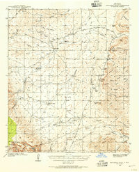 1940 Bandanna Point1955 Print · USGSEddy County ranching culture is frozen in time in the 1940s, showing a landscape defined by remote homesteads and critical water wells. Genealogists and historians can trace family land at Tatman Ranch or Pipkin Ranch and locate early landmarks like The Tepee.3 unique versions available
 - 1943 Map of Bandanna Point
 1943 Bandanna Point1943 Print · USGSEddy County ranching life during the early 1940s is centered on a vast network of family outposts and desert water holes. Researchers can locate established heritage sites like the Tatman Ranch and H Bar Y Ranch or trace early routes along the Panama Road.
End of results
Showing maps 1-2 of 2
Frequently asked questions
- What are the different types of historical maps available for Four Wells?
- What is the oldest map of Four Wells?
- Where can I purchase historical maps of Four Wells for my home or office?
- Where can I download high-res historical maps of Four Wells?
- Are there historical topographic maps available for Four Wells?
- Is there historical aerial imagery available for Four Wells?
- Where are historical maps of Four Wells sourced from?