Old Maps of Eddy County, New Mexico
Explore 509 old maps of Eddy County, spanning from 1935 to today. These high-resolution historic maps reveal how streets, neighborhoods, landmarks, and natural features evolved over time — perfect for genealogy, metal detecting, research, and local history exploration.
What you can do with these maps:
- See how Eddy County changed over time: Compare historical maps to modern-day views to trace roads, homesites, rail lines & more.
- View detailed metadata: Each map includes creators, publishers, year, scale, and archive source.
- Overlay maps with satellite & LiDAR: Visualize the past alongside modern tools to explore terrain & human change.
- Trusted historical sources: Maps sourced from the USGS, Library of Congress, and other archives.
- Access maps your way: View online, download high-res files, or order prints for personal or research use.
Start exploring old maps of Eddy County to uncover forgotten places, hidden landmarks, and the deep history beneath your feet.
Eddy County, NM maps
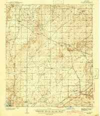
(509)- 1935 Map of El Paso Gap, 1954 Print
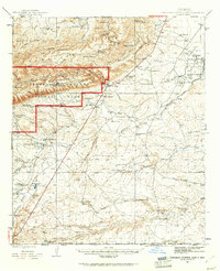
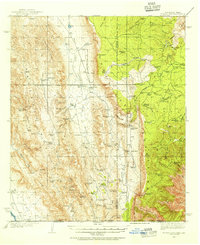 1935 El Paso Gap1954 Print · USGSThe Guadalupe Mountains of the mid-thirties are captured here as a landscape of isolated ranching outposts and vital water tanks. Genealogists and historians can trace family homesteads like Thayer Ranch and Carpenter Ranch, or locate the rural schoolhouses at Queen Sch and Dog Canyon Sch.2 unique versions available
 - 1936 Map of El Paso Gap
 1936 El Paso Gap1936 Print · USGSThe high desert ranching frontier along the New Mexico-Texas border is captured here during the mid-1930s. Researchers can locate remote schools and outposts like Queen Sch, the El Paso Gap PO, and family-named landmarks including Thayer Ranch.
 - 1939 Map of Carlsbad, 1955 Print
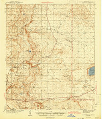
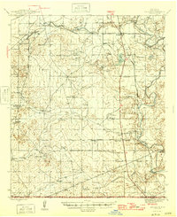
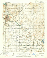 1939 Carlsbad1955 Print · USGSEddy County’s river-and-rail economy is captured here in the late 1930s, centered on the growing hub of Carlsbad. Researchers can trace the early footprint of the potash industry at the U S Potash Co Refinery and find local landmarks like the Harroun Sch and Forehand Ranch.2 unique versions available
 - 1939 Map of Nash Draw, 1971 Print
 1939 Nash Draw1971 Print · USGSEddy County’s desert landscape is captured here in the late 1930s, showing a critical period of early industrial mineral extraction. Local researchers can trace family-run operations at Crawford Ranch and James Ranch or locate the sprawling U.S. Potash Co Mine and Salt Lake.2 unique versions available
 - 1940 Map of El Paso Gap
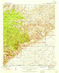
 1940 El Paso Gap1940 Print · USGSThe Guadalupe Mountains of southern New Mexico are shown in the mid-1930s, defined by a network of remote livestock ranches and isolated mountain schools. Genealogists and historians can trace family landholdings at Hepler Ranch or Lewis Ranch and locate vanished local landmarks like Queen Sch and the Old Post Place.3 unique versions available
 - 1940 Map of Bandanna Point, 1955 Print
 1940 Bandanna Point1955 Print · USGSEddy County ranching culture is frozen in time in the 1940s, showing a landscape defined by remote homesteads and critical water wells. Genealogists and historians can trace family land at Tatman Ranch or Pipkin Ranch and locate early landmarks like The Tepee.3 unique versions available
 - 1940 Map of Carlsbad Caverns West, 1955 Print
 1940 Carlsbad Caverns West1955 Print · USGSThe Guadalupe Mountains of southern New Mexico are shown here just before the mid-century, revealing a remote ranching and caving landscape. Researchers can trace early family outposts like Able Ranch and Thurman Ranch or locate the numerous karst features such as Mudgetts Cave and Painted Grotto.5 unique versions available
 - 1942 Map of Clayton Basin, 1958 Print
 1942 Clayton Basin1958 Print · USGSSoutheastern New Mexico's potash and ranching country comes to life in the years surrounding World War II. Researchers can locate family outposts like Lusk Ranch and Wood Ranch or trace the early industrial footprint of the Potash Co of America Mine.2 unique versions available
 - 1943 Map of Carlsbad
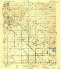 1943 Carlsbad1943 Print · USGSThe Pecos Valley during the early 1940s reveals a unique network of irrigation flumes and potash industrial sites. Researchers can trace family-named landmarks and rural infrastructure like Forehand Ranch, Harroun Sch, and the U S Potash Co Refinery.
 - 1943 Map of Clayton Basin
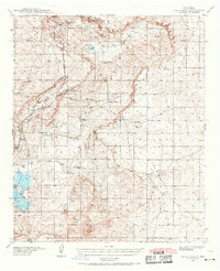
 1943 Clayton Basin1943 Print · USGSEddy and Lea Counties are mapped here during the early 1940s as the potash industry and ranching shaped the high desert landscape. Genealogists and historians can locate old cattle headquarters like Lusk Ranch and trace the spur of the Santa Fe Railroad (Oil City).2 unique versions available
 - 1943 Map of Carlsbad Caverns West
 1943 Carlsbad Caverns West1943 Print · USGSEddy County ranching outposts and the subterranean wonders of the Guadalupe Mountains are captured here in the early 1940s. Genealogists and historians can trace family land at Montgomery Ranch, visit the site of Queen (Ruins), or explore the springs at Sitting Bull Falls.
 - 1943 Map of Oil City
 1943 Oil City1943 Print · USGSEddy County, New Mexico, is captured here in the early 1940s, revealing a landscape of scattered ranches and emerging industry. Researchers can locate family landmarks like Angel Ranch and Mullman Ranch or trace the early U. S. Potash Reserve.3 unique versions available
 - 1943 Map of Bandanna Point
 1943 Bandanna Point1943 Print · USGSEddy County ranching life during the early 1940s is centered on a vast network of family outposts and desert water holes. Researchers can locate established heritage sites like the Tatman Ranch and H Bar Y Ranch or trace early routes along the Panama Road.
 - 1943 Map of Nash Draw
 1943 Nash Draw1943 Print · USGSEddy County’s potash mining industry is in full swing during the early 1940s, showcasing a landscape of industrial spurs and remote desert outposts. Trace the locations of the U. S. Potash Co Mine and isolated homesteads like Crawford Ranch or James Ranch.
 - 1943 Map of Texas Hill, 1960 Print
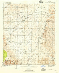
 1943 Texas Hill1960 Print · USGSThe high desert of Otero and Eddy counties is captured here in the mid-1940s, showcasing the isolated ranching life of the Guadalupe Mountains. Researchers can trace historic property boundaries and vital water sources like Hardin Ranch, A L Ranch, and Bates Windmill.2 unique versions available
 - 1943 Map of West Carlsbad, 1964 Print
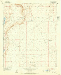
 1943 West Carlsbad1964 Print · USGSEddy County ranchlands and military installations come alive in this mid-century survey of the Pecos River valley. Genealogists and historians can trace family operations at Lovejoy Ranch and Kee Ranch, or locate the Golden Eagle Mine and the Carlsbad Army Air Field.2 unique versions available
 - 1945 Map of Texas Hill
 1945 Texas Hill1945 Print · USGSOtero County ranching culture is well-preserved here in the mid-1940s, showing a landscape defined by cattle operations and forest management. Researchers can trace historic family holdings like Hardin Ranch and A L Ranch or locate isolated structures such as Powers Shack.2 unique versions available
 - 1945 Map of West Carlsbad
 1945 West Carlsbad1945 Print · USGSEddy County ranching and military aviation meet in the mid-1940s as the Pecos River valley expands. Researchers can locate numerous historic homesteads like Lovejoy Ranch, the high-elevation Golden Eagle Mine, and the wartime Army Air Field.
 - 1945 Map of Carlsbad Caverns East, 1961 Print
 1945 Carlsbad Caverns East1961 Print · USGSSoutheast New Mexico in the mid-1940s reveals a rugged landscape of ranching outposts and high desert canyons. Genealogists and researchers can locate family sites like the W W Smith & Sons Ranch, explore the early footprint of White City, or find the Julian Smith Cem.2 unique versions available
 - 1945 Map of Malaga, 1970 Print
 1945 Malaga1970 Print · USGSEddy County ranchlands and river valleys are captured here at the end of the war, as the rail-and-ranch economy shaped southern New Mexico. Genealogists and historians can locate specific family holdings like the Delaware Ranch and Welch Ranch, alongside a vintage Bombing Target.
 - 1946 Map of Malaga
 1946 Malaga1946 Print · USGSSouthern New Mexico ranching and river life are frozen in time just after the war. Researchers can trace family ranch lands like Cottonwood Ranch and Reeves Ranch or locate unique landmarks like the Bombing Target and Harkey Double Mills.
 - 1947 Map of Carlsbad Caverns East
 1947 Carlsbad Caverns East1947 Print · USGSThe Guadalupe Mountains and the high desert of Eddy County are captured here just after the war. Researchers can trace early ranching boundaries and landmarks like White City, the Cavern Entrance, and a remote Bombing Target.
 - 1951 Map of Diamond Mound, 1953 Print
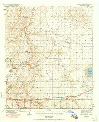
 1951 Diamond Mound1953 Print · USGSEddy and Chaves Counties are captured here in the early fifties, showing a landscape of high-desert ranching and alkaline basins. Researchers can locate remote outposts like Merritt Ranch and trace the drainage patterns of Derrick Draw and Flat Lake.
 - 1953 Map of Espuela, 1954 Print
 1953 Espuela1954 Print · USGSSoutheast New Mexico in the early fifties shows a landscape of artesian wells and shifting industry along the railroad. Researchers can locate the Cottonwood School, the Cottonwood Community Church, and the now-abandoned Walker Air Base Emergency Landing Field.2 unique versions available
 - 1953 Map of Basin Well, 1954 Print
 1953 Basin Well1954 Print · USGSSoutheast New Mexico ranching and oil exploration are documented here during the mid-fifties along the Chaves and Eddy County line. Researchers can locate remote desert water sources like Double Wells Tank and industrial markers ranging from a solitary Landing Strip to the High Lonesome Windmill.2 unique versions available
Showing maps 1-25 of 509
Top cities of Eddy County
- Carlsbad historical maps
- Artesia historical maps
- Loving historical maps
- Hope historical maps
- Whites City historical maps
Frequently asked questions
- What are the different types of historical maps available for Eddy County?
- What is the oldest map of Eddy County?
- Where can I purchase historical maps of Eddy County for my home or office?
- Where can I download high-res historical maps of Eddy County?
- Are there historical topographic maps available for Eddy County?
- Is there historical aerial imagery available for Eddy County?
- Where are historical maps of Eddy County sourced from?