1960s Maps of Eddy County, New Mexico
Explore 8 historic maps of Eddy County from the 1960s. These maps offer a rare glimpse into what life looked like during the 1960s — showing old roads, neighborhoods, homes, and landmarks that have changed or disappeared over time.
Whether you're researching your family's past, planning a metal detecting trip, or studying how Eddy County's landscape evolved across the 1960s, these high-resolution maps are a powerful tool for exploring the history of this region.
- Focus on a specific era: All maps on this page are from the 1960s, giving you a focused view of this time period.
- See what’s changed: Compare century-old streets, trails, and buildings to today's modern landscape using overlays and satellite layers.
- Research with precision: Use these maps for genealogy, historical research, land use analysis, or educational projects.
- View, download, or print: Maps are fully viewable online in high resolution, and can be downloaded or printed for your own records.
Start exploring Eddy County's history through authentic maps from the 1960s. This is your window into the past.
Eddy County, NM maps
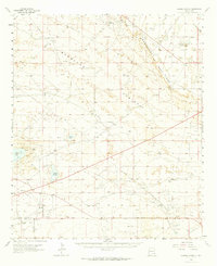
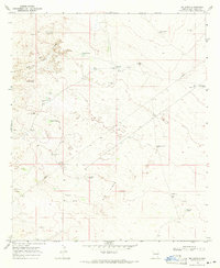
(8)- 1960 Map of Teel Ranch, 1964 Print
 1960 Teel Ranch1964 Print · USGSThe Chaves and Eddy county borderlands in the early sixties reveal a landscape of resilient family ranching and vital water infrastructure. Genealogists and historians can trace holdings like Teel Ranch, Harris Ranch, and the Schauer Landing Strip along the winding Rio Peñasco.
 - 1963 Map of Laguna Gatuna, 1965 Print
 1963 Laguna Gatuna1965 Print · USGSThe high plains of Lea County are defined by industrial growth and desert ranching in the early sixties. Researchers can trace family ranch lands like Smith Ranch and Alfred Ranch alongside the sprawling Corbin Oil Field and the Hobbs Air Force Base Auxiliary Field No 4.2 unique versions available
 - 1963 Map of Hat Mesa, 1965 Print
 1963 Hat Mesa1965 Print · USGSThe high plains of the New Mexico borderlands are captured in the early sixties as the ranching and oil economies began to overlap. Researchers can locate remote outposts like Brinninstool Ranch and trace vital water sources from Dagger Lake to Rogers Well.2 unique versions available
 - 1963 Map of Maljamar, 1965 Print
 1963 Maljamar1965 Print · USGSSoutheast New Mexico’s oil and ranching landscape is captured here in the early sixties, centered on the dramatic rise of The Caprock. Genealogists and historians can trace the footprint of early energy workers at Booker Camp and rural life at Bond Ranch or Youngs.2 unique versions available
 - 1968 Map of Pierce Canyon, 1971 Print
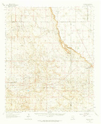
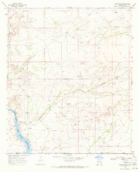
 1968 Pierce Canyon1971 Print · USGSThe Pecos River valley in Eddy County appears here during the late sixties, showing a landscape defined by irrigation and early oil expansion. Researchers can trace historic water routes like Harroun Canal and locate remote sites like Carper Windmill and the Pierce Canyon Crossing.
 - 1968 Map of Phantom Banks, 1971 Print
 1968 Phantom Banks1971 Print · USGSSoutheastern New Mexico's ranching and resource frontier is captured here in the late sixties, just as modern energy exploration began to mark the desert. Genealogists and historians can locate Steeple Ranch and trace the many water catchments like Big Seep Tank and Lone Tree Tank.2 unique versions available
 - 1968 Map of Big Sinks, 1971 Print
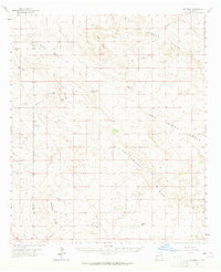
 1968 Big Sinks1971 Print · USGSEddy County ranching land is documented here in the late sixties, showcasing the remote water and wind infrastructure of the New Mexico desert. Researchers can trace land use through features like Twin Wells Ranch, Keyhole Windmill, and the depressions of the Big Sinks.
 - 1968 Map of Ross Ranch, 1971 Print
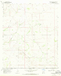
 1968 Ross Ranch1971 Print · USGSEddy County ranching and energy extraction are captured here in the late sixties, just as the regional pipeline network was expanding. Researchers can trace the layout of the Ross Ranch and the industrial activity near Rustler and the Pecos River Red Bluff Reservoir.
End of results
Showing maps 1-8 of 8
Top cities of Eddy County
- Carlsbad historical maps
- Artesia historical maps
- Loving historical maps
- Hope historical maps
- Whites City historical maps
Frequently asked questions
- What are the different types of historical maps available for Eddy County?
- What is the oldest map of Eddy County?
- Where can I purchase historical maps of Eddy County for my home or office?
- Where can I download high-res historical maps of Eddy County?
- Are there historical topographic maps available for Eddy County?
- Is there historical aerial imagery available for Eddy County?
- Where are historical maps of Eddy County sourced from?