
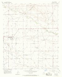
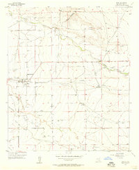
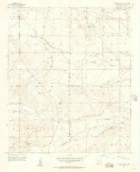
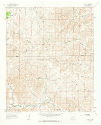
1960 Map of Teel Ranch
USGS Topo · Published 1964About this map
Rio Peñasco and the Rio Felix anchor this corner of southeast New Mexico, where water management is critical to the survival of high-plains ranching operations. The map documents an extensive network of family-owned holdings including the Teel Ranch, Hunter Ranch, and Joe Young Ranch, illustrating the sparse but vital settlement pattern of the Chaves and Eddy county borderlands. A distinct water infrastructure is visible through numerous wells and tanks such as Sixteen Tank and Dagger Tank, alongside the Hope West Dam and Hope Retard Dam which control seasonal flow along the western edge of the Hope Community.
Find a feature on this map
46 named features on this map. Tap any name to fly to it.
Don’t see what you’re looking for? This feature index may not catch every label — zoom into the map to look around manually.
Map Details
Editions of this 1960 Teel Ranch Map
This is the sole edition of this map. No revisions or reprints were ever made.
Other maps of this area

1954 · Carlsbad
USGS Topo · 1:250,000

1955 · Hope NW
USGS Topo · 1:24,000

1955 · Kincaid Ranch
USGS Topo · 1:24,000
1955 · Hope
USGS Topo · 1:24,000

1955 · Roswell
USGS Topo · 1:250,000
1956 · Hope
USGS Topo · 1:24,000
1956 · Antelope Sink
USGS Topo · 1:24,000

1958 · Carlsbad
USGS Topo · 1:250,000

1958 · Roswell
USGS Topo · 1:250,000
1961 · Flying H
USGS Topo · 1:62,500