
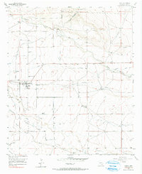
1956 Map of Hope
USGS Topo · Published 1957About this map
The agricultural settlement of Hope anchors this Eddy County landscape, revealing an intricate network of water management in the high desert of the 1950s. The map documents the vital role of irrigation through the Johnson Ditch and numerous unnamed ditches that crisscross the terrain, alongside evidence of shifting water use seen in the Abandoned Ditch and Abandoned Canal markings. These systems were essential for sustaining the isolated homesteads and livestock operations typical of the region, such as the Cole Place, Hunter Place, and Mc Ashan Ranch.
Find a feature on this map
18 named features on this map. Tap any name to fly to it.
Don’t see what you’re looking for? This feature index may not catch every label — zoom into the map to look around manually.
Map Details
Editions of this 1956 Hope Map
2 editions found
Other maps of this area

1954 · Carlsbad
USGS Topo · 1:250,000

1955 · Hope NW
USGS Topo · 1:24,000

1955 · Hope NE
USGS Topo · 1:24,000

1955 · Hope
USGS Topo · 1:24,000

1956 · Parish Ranch
USGS Topo · 1:24,000

1956 · Antelope Sink
USGS Topo · 1:24,000

1956 · Hope SE
USGS Topo · 1:24,000

1958 · Carlsbad
USGS Topo · 1:250,000

1960 · Teel Ranch
USGS Topo · 1:62,500

1978 · Artesia
USGS Topo · 1:100,000