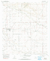
1956 Map of Hope
USGS Topo · Published 1990About this map
The agricultural settlement of Hope anchors this mid-century New Mexico landscape, defined by an intricate network of irrigation canals and intermittent watercourses. The reliance on water management is evident in the extensive labeling of ditches, including the Johnson Ditch, which redirect flow toward farmsteads in this arid region. The terrain is carved by numerous draws, most notably Eagle Draw, Catclaw Draw, and Rio Penasco Draw, which converge toward the Rio Penasco.
Find a feature on this map
20 named features on this map. Tap any name to fly to it.
Don’t see what you’re looking for? This feature index may not catch every label — zoom into the map to look around manually.
Map Details
Editions of this 1956 Hope Map
2 editions found
Other maps of this area

1954 · Carlsbad
USGS Topo · 1:250,000

1955 · Hope NW
USGS Topo · 1:24,000

1955 · Hope NE
USGS Topo · 1:24,000

1955 · Hope
USGS Topo · 1:24,000

1956 · Hope
USGS Topo · 1:24,000

1956 · Parish Ranch
USGS Topo · 1:24,000

1956 · Antelope Sink
USGS Topo · 1:24,000

1956 · Hope SE
USGS Topo · 1:24,000

1958 · Carlsbad
USGS Topo · 1:250,000

1960 · Teel Ranch
USGS Topo · 1:62,500