1990s Maps of White Signal, New Mexico
Explore 2 historic maps of White Signal from the 1990s. These maps offer a rare glimpse into what life looked like during the 1990s — showing old roads, neighborhoods, homes, and landmarks that have changed or disappeared over time.
Whether you're researching your family's past, planning a metal detecting trip, or studying how White Signal's landscape evolved across the 1990s, these high-resolution maps are a powerful tool for exploring the history of this region.
- Focus on a specific era: All maps on this page are from the 1990s, giving you a focused view of this time period.
- See what’s changed: Compare century-old streets, trails, and buildings to today's modern landscape using overlays and satellite layers.
- Research with precision: Use these maps for genealogy, historical research, land use analysis, or educational projects.
- View, download, or print: Maps are fully viewable online in high resolution, and can be downloaded or printed for your own records.
Start exploring White Signal's history through authentic maps from the 1990s. This is your window into the past.
White Signal, NM maps
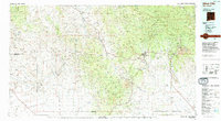
(2)- 1992 Map of White Signal
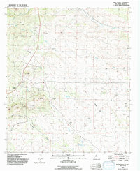 1992 White Signal1992 Print · USGSWhite Signal and the surrounding Burro Mountains are captured here in the early nineties during a period of sustained mining interest. Researchers and genealogists can trace numerous mineral claims like the Gold Lake Mine and Apache Trail Mine or find the remote Grave site near Keese Canyon.
 - 1994 Map of Silver City
 1994 Silver City1994 Print · USGSThe mining heart of Grant County is revealed in the mid-1990s as the massive industrial footprints of the copper industry shaped the landscape. Genealogists and historians can trace the rail lines of the Atchison Topeka and Santa Fe RR or locate landmarks like Fort Bayard State Medical Center and White Signal.
End of results
Showing maps 1-2 of 2
Top cities near White Signal
Frequently asked questions
- What are the different types of historical maps available for White Signal?
- What is the oldest map of White Signal?
- Where can I purchase historical maps of White Signal for my home or office?
- Where can I download high-res historical maps of White Signal?
- Are there historical topographic maps available for White Signal?
- Is there historical aerial imagery available for White Signal?
- Where are historical maps of White Signal sourced from?