Old Maps of Mills, New Mexico for Hiking & Exploration
Hike through history with 10 historic maps of Mills. Explore old trails, ghost towns, and forgotten backroads — perfect for outdoor adventurers and local explorers.
- Rediscover forgotten places: Map out old mining camps, roads, and footpaths that no longer exist on modern maps.
- Layer with modern tools: Combine with LiDAR or satellite views to plan hikes through historical terrain.
- Made for exploration: Popular among hikers, overlanders, and local history lovers.
Use these maps to find adventure and explore the hidden past of Mills.
Mills, NM maps
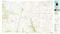
(10)- 1954 Map of Raton, 1963 Print
 1954 Raton1963 Print · USGSNorthern New Mexico's high-country and plains are documented here in the early sixties, showing the region's ranching and mining infrastructure. Trace the legacy of the Maxwell Land Grant, locate remote rural sites like Tafoya School, and follow the Atchison Topeka and Santa Fe Railway through the heart of Raton.3 unique versions available
 - 1958 Map of Raton
 1958 Raton1958 Print · USGSNorthern New Mexico and the Colorado borderlands are mapped here in the late fifties, showcasing a landscape of high peaks and historic land grants. Genealogists and historians can trace families across Picuris Pueblo, find old schoolhouses like Piedra Lumbre School, or follow the Atchison Topeka and Santa Fe rail line.3 unique versions available
 - 1972 Map of Mills West, 1975 Print
 1972 Mills West1975 Print · USGSHarding County ranchlands and the deep breaks of the Canadian River define this area during the early seventies. Genealogists and local historians can trace the Old Railroad Grade past Mills or locate the remote Mesteñito Cem.
 - 1981 Map of Springer
 1981 Springer1981 Print · USGSNortheast New Mexico in the early eighties remains a landscape defined by its deep historical pathways and massive land grants. Genealogists and historians can trace the original Santa Fe Trail routes, the State Boys School at Springer, and the landmarks of Wagon Mound.
 - 1998 Map of Mills West, 2001 Print
 1998 Mills West2001 Print · USGSHarding County’s high plains and deep canyons are documented here in the late nineties, showcasing a remote ranching landscape. You can locate the Mesteñito Cem and trace the settlement at Mills alongside the dramatic breaks of the Canadian River.
 - 2011 Map of Mills West, 2011 Print
 2011 Mills West2011 Print · USGSCovers Mills, including Harding County, Mora County, and other nearby areas
 - 2013 Map of Mills West, 2013 Print
 2013 Mills West2013 Print · USGSCovers Mills, including Harding County, Mora County, and other nearby areas
 - 2017 Map of Mills West, 2017 Print
 2017 Mills West2017 Print · USGSCovers Mills, including Harding County, Mora County, and other nearby areas
 - 2020 Map of Mills West, 2020 Print
 2020 Mills West2020 Print · USGSCovers Mills, including Harding County, Mora County, and other nearby areas
 - 2023 Map of Mills West, 2023 Print
 2023 Mills West2023 Print · USGSHarding and Mora counties in northeastern New Mexico are captured here in a period defined by ranching and public grasslands. Researchers can trace family history at Mestenito Cem or explore the rugged topography of the Canadian River and Mills.
End of results
Showing maps 1-10 of 10
Top cities near Mills
Frequently asked questions
- What are the different types of historical maps available for Mills?
- What is the oldest map of Mills?
- Where can I purchase historical maps of Mills for my home or office?
- Where can I download high-res historical maps of Mills?
- Are there historical topographic maps available for Mills?
- Is there historical aerial imagery available for Mills?
- Where are historical maps of Mills sourced from?