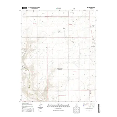
2013 Map of Mills West
USGS Topo · Published 2013About this map
Kiowa National Grassland dominates this section of the High Plains, where the open prairie is sharply incised by the Canadian River and its tributary canyons. The landscape is defined by deep geological features such as Cañon Mestenito and Cañon Vercere, which provide a stark contrast to the surrounding Mestenito Valley. Evidence of ranching and early settlement persists in labels for Gonzales, Abernathy, and Gates, while the Mestenito Cem serves as a quiet marker of the area's residents. Near the eastern edge, the settlement of Mills and the nearby Orchard Ranch represent the persistent agricultural presence along State Hwy 39. The map also highlights the Mills Canyon Campground, reflecting the modern use of this dramatic terrain for public recreation within the federal grassland system.
Find a feature on this map
29 named features on this map. Tap any name to fly to it.
Don’t see what you’re looking for? This feature index may not catch every label — zoom into the map to look around manually.
Map Details
Editions of this 2013 Mills West Map
This is the sole edition of this map. No revisions or reprints were ever made.
Other maps of this area

1954 · Santa Fe
USGS Topo · 1:250,000

1954 · Raton
USGS Topo · 1:250,000

1958 · Raton
USGS Topo · 1:250,000

1958 · Santa Fe
USGS Topo · 1:250,000

1971 · Abbott Lake
USGS Topo · 1:24,000

1971 · Beaver Canyon
USGS Topo · 1:24,000

1971 · Canon Las Cuevas
USGS Topo · 1:24,000

1972 · Canon Colorado
USGS Topo · 1:24,000
1972 · Jaritas Ranch
USGS Topo · 1:24,000

1972 · Mills West
USGS Topo · 1:24,000