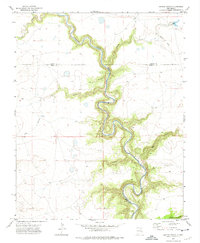
1972 Map of Jaritas Ranch
USGS Topo · Published 1975About this map
The Canadian River carves a deep, serpentine path through the high plains of northeastern New Mexico, defining the borders where Mora, Colfax, and Harding Counties meet. This 1970s landscape is dominated by the sprawling Jaritas Ranch and a complex network of side canyons, including Pup Canyon, Dog Canyon, and Lodge Canyon, which drain into the river's entrenched valley. A significant historical marker is the Old Railroad Grade winding through the northeastern corner, indicating a former rail corridor that once linked this cattle country to broader markets.
Find a feature on this map
15 named features on this map. Tap any name to fly to it.
Don’t see what you’re looking for? This feature index may not catch every label — zoom into the map to look around manually.
Map Details
Editions of this 1972 Jaritas Ranch Map
This is the sole edition of this map. No revisions or reprints were ever made.
Other maps of this area

1954 · Raton
USGS Topo · 1:250,000

1958 · Raton
USGS Topo · 1:250,000

1964 · Stony Lake
USGS Topo · 1:24,000

1964 · Alto De Hormiga
USGS Topo · 1:24,000

1965 · Taylor Springs
USGS Topo · 1:24,000

1965 · Abbott
USGS Topo · 1:24,000

1965 · Springer
USGS Topo · 1:24,000

1971 · Abbott Lake
USGS Topo · 1:24,000

1972 · Canon Colorado
USGS Topo · 1:24,000

1972 · Mills West
USGS Topo · 1:24,000