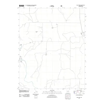
2011 Map of Mills West
USGS Topo · Published 2011About this map
Mestenito Valley and the surrounding high plains of Harding County are documented here in detail, showcasing a landscape defined by ranching and the deep incision of the Canadian River. The terrain is marked by significant geological features including Cañon Mestenito and Cañon Vercere, which provide a stark contrast to the flat-topped mesas. Local history is anchored by the Mestenito Cemetery and several named homesteads and settlements such as Gonzales, Abernathy, and Main. On the eastern edge, the community of Mills is visible, alongside the Orchard Ranch. For those interested in the recreational use of this rugged landscape, the Mills Canyon Campground is situated near the river, reflecting the area's transition into a space for conservation and public access. The map reveals a network of rural routes, including Berner Rd and various county roads, that connect these remote outposts.
Find a feature on this map
21 named features on this map. Tap any name to fly to it.
Don’t see what you’re looking for? This feature index may not catch every label — zoom into the map to look around manually.
Map Details
Editions of this 2011 Mills West Map
This is the sole edition of this map. No revisions or reprints were ever made.
Other maps of this area

1954 · Santa Fe
USGS Topo · 1:250,000

1954 · Raton
USGS Topo · 1:250,000

1958 · Raton
USGS Topo · 1:250,000

1958 · Santa Fe
USGS Topo · 1:250,000

1971 · Abbott Lake
USGS Topo · 1:24,000

1971 · Beaver Canyon
USGS Topo · 1:24,000

1971 · Canon Las Cuevas
USGS Topo · 1:24,000

1972 · Canon Colorado
USGS Topo · 1:24,000
1972 · Jaritas Ranch
USGS Topo · 1:24,000

1972 · Mills West
USGS Topo · 1:24,000