1910s Maps of Mimbres, New Mexico
Explore 2 historic maps of Mimbres from the 1910s. These maps offer a rare glimpse into what life looked like during the 1910s — showing old roads, neighborhoods, homes, and landmarks that have changed or disappeared over time.
Whether you're researching your family's past, planning a metal detecting trip, or studying how Mimbres's landscape evolved across the 1910s, these high-resolution maps are a powerful tool for exploring the history of this region.
- Focus on a specific era: All maps on this page are from the 1910s, giving you a focused view of this time period.
- See what’s changed: Compare century-old streets, trails, and buildings to today's modern landscape using overlays and satellite layers.
- Research with precision: Use these maps for genealogy, historical research, land use analysis, or educational projects.
- View, download, or print: Maps are fully viewable online in high resolution, and can be downloaded or printed for your own records.
Start exploring Mimbres's history through authentic maps from the 1910s. This is your window into the past.
Mimbres, NM maps
(2)- 1917 Map of Hermanas
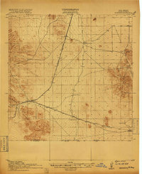 1917 Hermanas1917 Print · USGSSouthern New Mexico was a critical frontier at the time of the Great War, defined by cattle ranching and international border security. Researchers can trace the path of the El Paso and Southwestern Road and locate remote outposts like Dogtown Ranch, Mahoney, and Hermanas.
 - 1918 Map of Hermanas
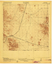 1918 Hermanas1918 Print · USGSThis Luna County borderland is shown just as the ranching and railroad era reached its height along the Mexican border. Genealogists and historians can trace the early cattle operations of Dogtown Ranch and Hoppy Ranch or follow the tracks of the El Paso and Southwestern Road.
End of results
Showing maps 1-2 of 2
Top cities near Mimbres
Frequently asked questions
- What are the different types of historical maps available for Mimbres?
- What is the oldest map of Mimbres?
- Where can I purchase historical maps of Mimbres for my home or office?
- Where can I download high-res historical maps of Mimbres?
- Are there historical topographic maps available for Mimbres?
- Is there historical aerial imagery available for Mimbres?
- Where are historical maps of Mimbres sourced from?