1800s (19th Century) Maps of Tiptonville, New Mexico
Explore 2 historic maps of Tiptonville from the 1800s (19th Century). These maps offer a rare glimpse into what life looked like during the 1800s — showing old roads, neighborhoods, homes, and landmarks that have changed or disappeared over time.
Whether you're researching your family's past, planning a metal detecting trip, or studying how Tiptonville's landscape evolved across the 1800s, these high-resolution maps are a powerful tool for exploring the history of this region.
- Focus on a specific era: All maps on this page are from the 1800s, giving you a focused view of this time period.
- See what’s changed: Compare century-old streets, trails, and buildings to today's modern landscape using overlays and satellite layers.
- Research with precision: Use these maps for genealogy, historical research, land use analysis, or educational projects.
- View, download, or print: Maps are fully viewable online in high resolution, and can be downloaded or printed for your own records.
Start exploring Tiptonville's history through authentic maps from the 1800s. This is your window into the past.
Tiptonville, NM maps
(2)- 1892 Map of Watrous
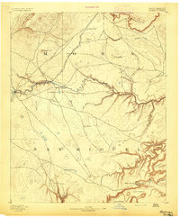 1892 Watrous1892 Print · USGSNortheastern New Mexico comes into focus during the expansion of the western frontier, showing the critical junction of the railroad and the river. Trace nineteenth-century ranching life and travel stops at Watrous, the O. K. Ranch, and a remote Blacksmith Shop.
 - 1894 Map of Watrous
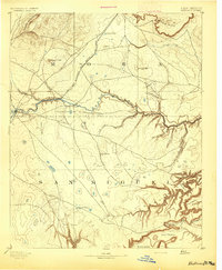 1894 Watrous1894 Print · USGSNorthern New Mexico at the end of the nineteenth century was a landscape of pioneering rail lines and cattle ranches. You can trace the Atchison Topeka and Santa Fe Railroad as it services Watrous and Shoemaker or locate the remote O.K. Ranch.5 unique versions available
End of results
Showing maps 1-2 of 2
Top cities near Tiptonville
Frequently asked questions
- What are the different types of historical maps available for Tiptonville?
- What is the oldest map of Tiptonville?
- Where can I purchase historical maps of Tiptonville for my home or office?
- Where can I download high-res historical maps of Tiptonville?
- Are there historical topographic maps available for Tiptonville?
- Is there historical aerial imagery available for Tiptonville?
- Where are historical maps of Tiptonville sourced from?