1980s Maps of Apache, New Mexico
Explore 2 historic maps of Apache from the 1980s. These maps offer a rare glimpse into what life looked like during the 1980s — showing old roads, neighborhoods, homes, and landmarks that have changed or disappeared over time.
Whether you're researching your family's past, planning a metal detecting trip, or studying how Apache's landscape evolved across the 1980s, these high-resolution maps are a powerful tool for exploring the history of this region.
- Focus on a specific era: All maps on this page are from the 1980s, giving you a focused view of this time period.
- See what’s changed: Compare century-old streets, trails, and buildings to today's modern landscape using overlays and satellite layers.
- Research with precision: Use these maps for genealogy, historical research, land use analysis, or educational projects.
- View, download, or print: Maps are fully viewable online in high resolution, and can be downloaded or printed for your own records.
Start exploring Apache's history through authentic maps from the 1980s. This is your window into the past.
Apache, NM maps
(2)- 1981 Map of Golondrina Draw, 1982 Print
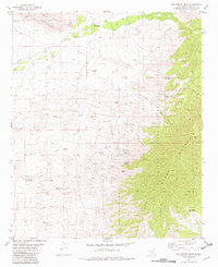 1981 Golondrina Draw1982 Print · USGSHigh-desert ranching and tribal lands in Otero County are documented here as they appeared in the early eighties. Researchers can locate remote sites like the Santo Niño de Atocha Ch Cem, Schoolhouse Well, and the Golondrina Windmill.
 - 1984 Map of Ruidoso
 1984 Ruidoso1984 Print · USGSThe high country of the Sierra Blanca and the Lincoln National Forest are captured here in the mid-eighties as tourism and traditional land use converged. Local historians can trace the Old Military Reservation Boundary, find historic workings like the Parsons Mine, or locate small communities such as Glencoe and Whitetail.
End of results
Showing maps 1-2 of 2
Top cities near Apache
Frequently asked questions
- What are the different types of historical maps available for Apache?
- What is the oldest map of Apache?
- Where can I purchase historical maps of Apache for my home or office?
- Where can I download high-res historical maps of Apache?
- Are there historical topographic maps available for Apache?
- Is there historical aerial imagery available for Apache?
- Where are historical maps of Apache sourced from?