1960s Maps of Camp Geronimo, New Mexico
Explore 2 historic maps of Camp Geronimo from the 1960s. These maps offer a rare glimpse into what life looked like during the 1960s — showing old roads, neighborhoods, homes, and landmarks that have changed or disappeared over time.
Whether you're researching your family's past, planning a metal detecting trip, or studying how Camp Geronimo's landscape evolved across the 1960s, these high-resolution maps are a powerful tool for exploring the history of this region.
- Focus on a specific era: All maps on this page are from the 1960s, giving you a focused view of this time period.
- See what’s changed: Compare century-old streets, trails, and buildings to today's modern landscape using overlays and satellite layers.
- Research with precision: Use these maps for genealogy, historical research, land use analysis, or educational projects.
- View, download, or print: Maps are fully viewable online in high resolution, and can be downloaded or printed for your own records.
Start exploring Camp Geronimo's history through authentic maps from the 1960s. This is your window into the past.
Camp Geronimo, NM maps
(2)- 1962 Map of Roswell
 1962 Roswell1962 Print · USGSSoutheastern New Mexico in the early sixties shows a landscape defined by high mountain peaks and a growing military presence at Roswell. Genealogists and historians can trace the roads connecting Fort Stanton, Capitan, and the Mescalero Apache Indian Reservation.
 - 1963 Map of Elk-Silver, 1967 Print
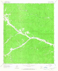 1963 Elk-Silver1967 Print · USGSThe Mescalero Apache Indian Reservation and Lincoln National Forest meet in the 1960s, showing a network of high canyons and vital water tanks. Trace the road to Elk-Silver or locate remote sites like Camp Geronimo and Solon Dam.2 unique versions available
End of results
Showing maps 1-2 of 2
Top cities near Camp Geronimo
Frequently asked questions
- What are the different types of historical maps available for Camp Geronimo?
- What is the oldest map of Camp Geronimo?
- Where can I purchase historical maps of Camp Geronimo for my home or office?
- Where can I download high-res historical maps of Camp Geronimo?
- Are there historical topographic maps available for Camp Geronimo?
- Is there historical aerial imagery available for Camp Geronimo?
- Where are historical maps of Camp Geronimo sourced from?