1900s (20th Century) Maps of Tucumcari, New Mexico
Explore 6 historic maps of Tucumcari from the 1900s (20th Century). These maps offer a rare glimpse into what life looked like during the 1900s — showing old roads, neighborhoods, homes, and landmarks that have changed or disappeared over time.
Whether you're researching your family's past, planning a metal detecting trip, or studying how Tucumcari's landscape evolved across the 1900s, these high-resolution maps are a powerful tool for exploring the history of this region.
- Focus on a specific era: All maps on this page are from the 1900s, giving you a focused view of this time period.
- See what’s changed: Compare century-old streets, trails, and buildings to today's modern landscape using overlays and satellite layers.
- Research with precision: Use these maps for genealogy, historical research, land use analysis, or educational projects.
- View, download, or print: Maps are fully viewable online in high resolution, and can be downloaded or printed for your own records.
Start exploring Tucumcari's history through authentic maps from the 1900s. This is your window into the past.
Tucumcari, NM maps
(6)- 1930 Map of Tucumcari
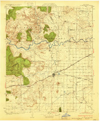 1930 Tucumcari1930 Print · USGSTucumcari and the surrounding ranch lands of eastern New Mexico are captured here during the peak of the steam rail era. Genealogists and historians can trace family-named sites like the Elliott Ranch, remote schools such as Bryantine Sch, and the winding Canadian River corridor.2 unique versions available
 - 1954 Map of Tucumcari, 1965 Print
 1954 Tucumcari1965 Print · USGSThe high plains along the New Mexico and Texas border come alive in this mid-century survey, just as the regional highway network was maturing. Trace the historic route of U.S. 66 through Glenrio and San Jon or locate remote rail sidings like Rehm Station and Obar.2 unique versions available
 - 1958 Map of Tucumcari
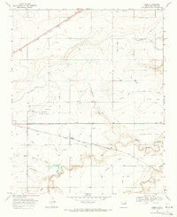
 1958 Tucumcari1958 Print · USGSEastern New Mexico and the Texas Panhandle meet in this mid-century survey of the high plains ranching and rail corridor. Researchers can trace the path of Mother Road travelers through Tucumcari and Glenrio or locate remote rail stops like Nara Visa Station and Hartley Station.
 - 1967 Map of Liberty Mesa, 1971 Print
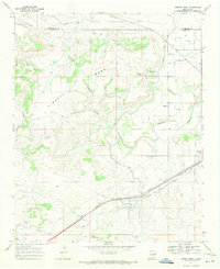 1967 Liberty Mesa1971 Print · USGSQuay County ranching and rail infrastructure are on full display during the late sixties, showing the vital irrigation networks north of Tucumcari. Genealogists and historians can trace family landmarks like the Leslie Windmill or local sites such as the Drive-in Theater and Liberty.
 - 1967 Map of Tucumcari, 1971 Print
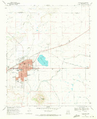 1967 Tucumcari1971 Print · USGSTucumcari was a vital rail and ranching center in the late sixties, where the high plains meet essential irrigation networks. Researchers can trace the development of the city's schools and neighborhoods near landmarks like Tucumcari Mountain and Tucumcari Lake.
 - 1968 Map of Lesbia, 1971 Print
 1968 Lesbia1971 Print · USGSQuay County in the late sixties reveals an arid landscape transformed by a sophisticated network of family-named irrigation ditches and rail infrastructure. Genealogists and local historians can trace the paths of the Jones Lateral, the Simmons Lateral, and the settlement at Lesbia along the railroad line.
End of results
Showing maps 1-6 of 6
Frequently asked questions
- What are the different types of historical maps available for Tucumcari?
- What is the oldest map of Tucumcari?
- Where can I purchase historical maps of Tucumcari for my home or office?
- Where can I download high-res historical maps of Tucumcari?
- Are there historical topographic maps available for Tucumcari?
- Is there historical aerial imagery available for Tucumcari?
- Where are historical maps of Tucumcari sourced from?