
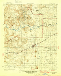
1930 Map of Tucumcari
USGS Topo · Published 1930About this map
Tucumcari serves as the focal point of this late 1920s landscape, positioned at the critical junction of the Southern Pacific and Chicago Rock Island and Pacific railroads. The map reveals a transition from the structured land divisions of the Pablo Montoya Grant and Baca Location No 2 to the open ranching country defined by family operations like the Dan Todd Ranch and Curry Ranch. To the north, the Canadian River carves through the terrain below Carpenter Mesa, while the southern expanse is dotted with rural educational hubs including Plaza Larga Sch and Lloyd Sch. The presence of established outposts such as Bascom Camp and Carros Camp suggests a landscape still deeply rooted in seasonal grazing and early 20th-century commerce, anchored by the prominent silhouette of Tucumcari Mtn.
Find a feature on this map
40 named features on this map. Tap any name to fly to it.
Don’t see what you’re looking for? This feature index may not catch every label — zoom into the map to look around manually.
Map Details
Editions of this 1930 Tucumcari Map
2 editions found
Other maps of this area

1954 · Santa Fe
USGS Topo · 1:250,000

1954 · Fort Sumner
USGS Topo · 1:250,000

1954 · Tucumcari
USGS Topo · 1:250,000

1954 · Clovis
USGS Topo · 1:250,000

1958 · Fort Sumner
USGS Topo · 1:250,000

1958 · Santa Fe
USGS Topo · 1:250,000

1958 · Clovis
USGS Topo · 1:250,000

1958 · Tucumcari
USGS Topo · 1:250,000

1962 · Logan
USGS Topo · 1:62,500

1964 · Muniz Canyon
USGS Topo · 1:24,000