
Loading...
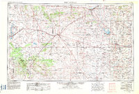
Loading map...1958 Map of Fort Sumner
USGS Topo · Published 1958About this map
Pecos River drainage and the vast high plains of east-central New Mexico define this mid-century survey. The landscape is a network of cattle ranches and high mesas, where the Alamogordo Reservoir serves as a critical water landmark north of the regional hub of Santa Rosa. Transportation is dominated by the intersection of major rail lines and highways, with the Atchison Topeka and Santa Fe and Southern Pacific railroads converging near Vaughn.
Find a feature on this map
146 named features on this map. Tap any name to fly to it.
Don’t see what you’re looking for? This feature index may not catch every label — zoom into the map to look around manually.
Map Details
Date Portrayed1958
Date Published1958
PublisherU.S. Geological Survey
Map TypeTopographic
Scale1:250,000
Physical Dimensions34 x 22.1 inches
Editions of this 1958 Fort Sumner Map
This is the sole edition of this map. No revisions or reprints were ever made.
Historical Maps of Santa Rosa Through Time
3 maps found
Featured Locations
Source Details
SourceU.S. Geological Survey
CopyrightPublic Domain