1970s Maps of Causey, New Mexico
Explore 4 historic maps of Causey from the 1970s. These maps offer a rare glimpse into what life looked like during the 1970s — showing old roads, neighborhoods, homes, and landmarks that have changed or disappeared over time.
Whether you're researching your family's past, planning a metal detecting trip, or studying how Causey's landscape evolved across the 1970s, these high-resolution maps are a powerful tool for exploring the history of this region.
- Focus on a specific era: All maps on this page are from the 1970s, giving you a focused view of this time period.
- See what’s changed: Compare century-old streets, trails, and buildings to today's modern landscape using overlays and satellite layers.
- Research with precision: Use these maps for genealogy, historical research, land use analysis, or educational projects.
- View, download, or print: Maps are fully viewable online in high resolution, and can be downloaded or printed for your own records.
Start exploring Causey's history through authentic maps from the 1970s. This is your window into the past.
Causey, NM maps
(4)- 1970 Map of Lingo, 1972 Print
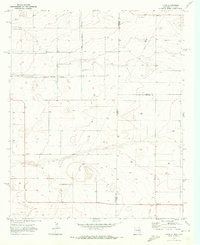 1970 Lingo1972 Print · USGSThe High Plains at the New Mexico and Texas border come alive in the early seventies, showing a landscape defined by ranching and resource extraction. Trace the footprint of small settlements like Lingo and Griffith alongside a Landing Field and a local Gravel pit.
 - 1970 Map of Causey East, 1973 Print
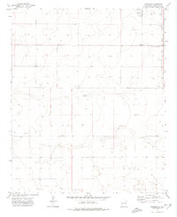
 1970 Causey East1973 Print · USGSThe high plains of the New Mexico-Texas border come into focus in the early seventies, centered on the village of Causey. Genealogists and researchers can trace the Causey Corporate Boundary, locate the local Cem, and find industrial markers like the Pumping Sta.
 - 1972 Map of Garrison, 1975 Print
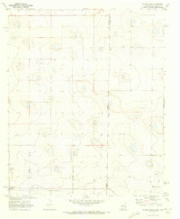
 1972 Garrison1975 Print · USGSRoosevelt County's high plains are captured here in the early seventies, showing a quiet landscape of isolated wells and rural boundary lines. Researchers can pinpoint the Causey Cem and the small settlement of Garrison, or trace the Causey Corporate Boundary.
 - 1972 Map of Causey West, 1975 Print
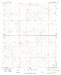 1972 Causey West1975 Print · USGSRoosevelt County ranching and farming communities are mapped in the early seventies along the Texas border. Trace family roots and land use near Causey, the Longs Cem, and the small settlement of Rogers.2 unique versions available
End of results
Showing maps 1-4 of 4
Top cities near Causey
Frequently asked questions
- What are the different types of historical maps available for Causey?
- What is the oldest map of Causey?
- Where can I purchase historical maps of Causey for my home or office?
- Where can I download high-res historical maps of Causey?
- Are there historical topographic maps available for Causey?
- Is there historical aerial imagery available for Causey?
- Where are historical maps of Causey sourced from?