1800s (19th Century) Maps of Lagunas, New Mexico
Explore 3 historic maps of Lagunas from the 1800s (19th Century). These maps offer a rare glimpse into what life looked like during the 1800s — showing old roads, neighborhoods, homes, and landmarks that have changed or disappeared over time.
Whether you're researching your family's past, planning a metal detecting trip, or studying how Lagunas's landscape evolved across the 1800s, these high-resolution maps are a powerful tool for exploring the history of this region.
- Focus on a specific era: All maps on this page are from the 1800s, giving you a focused view of this time period.
- See what’s changed: Compare century-old streets, trails, and buildings to today's modern landscape using overlays and satellite layers.
- Research with precision: Use these maps for genealogy, historical research, land use analysis, or educational projects.
- View, download, or print: Maps are fully viewable online in high resolution, and can be downloaded or printed for your own records.
Start exploring Lagunas's history through authentic maps from the 1800s. This is your window into the past.
Lagunas, NM maps
(3)- 1889 Map of Las Vegas, 1953 Print
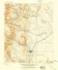 1889 Las Vegas1953 Print · USGSNorthern New Mexico in the late nineteenth century is documented here as the railroad brought new life to the high plains. Researchers can trace the early layout of Las Vegas, find the strategic site of Fort Union, and locate vanished plazas like Loma Parda.
 - 1891 Map of Las Vegas
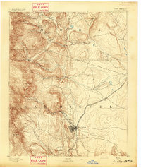
 1891 Las Vegas1891 Print · USGSNorthern New Mexico's transition from frontier outposts to a rail-connected territory is visible in this survey from the late nineteenth century. Genealogists and historians can trace the foundations of Las Vegas and its connection to Fort Union and Hot Springs.
 - 1893 Map of Las Vegas
 1893 Las Vegas1893 Print · USGSSan Miguel and Mora counties are captured here in the final decade of the nineteenth century as the railroad transformed the territory. Trace early travel routes through Las Vegas and locate historic outposts like Fort Union and La Cueva.5 unique versions available
End of results
Showing maps 1-3 of 3
Top cities near Lagunas
Frequently asked questions
- What are the different types of historical maps available for Lagunas?
- What is the oldest map of Lagunas?
- Where can I purchase historical maps of Lagunas for my home or office?
- Where can I download high-res historical maps of Lagunas?
- Are there historical topographic maps available for Lagunas?
- Is there historical aerial imagery available for Lagunas?
- Where are historical maps of Lagunas sourced from?