Old Maps of Corrales, New Mexico
Explore 44 old maps of Corrales, spanning from 1888 to today. These high-resolution historic maps reveal how streets, neighborhoods, landmarks, and natural features evolved over time — perfect for genealogy, metal detecting, research, and local history exploration.
What you can do with these maps:
- See how Corrales changed over time: Compare historical maps to modern-day views to trace roads, homesites, rail lines & more.
- View detailed metadata: Each map includes creators, publishers, year, scale, and archive source.
- Overlay maps with satellite & LiDAR: Visualize the past alongside modern tools to explore terrain & human change.
- Trusted historical sources: Maps sourced from the USGS, Library of Congress, and other archives.
- Access maps your way: View online, download high-res files, or order prints for personal or research use.
Start exploring old maps of Corrales to uncover forgotten places, hidden landmarks, and the deep history beneath your feet.
Corrales, NM maps
(44)- 1888 Map of Bernalillo, 1951 Print
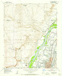
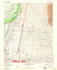
 1888 Bernalillo1951 Print · USGSThe Middle Rio Grande valley appears here in the late nineteenth century, just as the railroad began to reshape the high desert. Genealogists and historians can trace the early footprints of Albuquerque, Bernalillo, and traditional communities like Atrisco and Santa Ana.
 - 1889 Map of Albuquerque
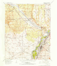
 1889 Albuquerque1889 Print · USGSAlbuquerque and the Rio Grande Valley appear here during the expansion of the territorial railroad system. Local historians can trace the early rail corridor of the Atchison Topeka and Santa Fe Railroad and find early river settlements like Bernalillo, Alameda, and Artisco.
 - 1893 Map of Albuquerque
 1893 Albuquerque1893 Print · USGSThe Rio Grande valley in the late nineteenth century is a study in river-fronting settlements and the emerging rail economy. Genealogists can trace the early footprints of Albuquerque, Bernalillo, and the traditional community at Artisco.5 unique versions available
 - 1934 Map of Alameda
 1934 Alameda1934 Print · USGSThe Rio Grande valley in the mid-1930s reveals a landscape of deep-rooted land grants and modernizing infrastructure. Genealogists and historians can trace the irrigation ditches around Alameda and find landmarks like the Nazareth Sanatorium and KOB Radio Transmitter.
 - 1934 Map of Griegos
 1934 Griegos1934 Print · USGSThe Rio Grande valley north of Albuquerque is shown here in the mid-thirties as a landscape of historic land grants and complex irrigation. Genealogists and historians can trace the early rail-and-road network near Hahn Station and the Alameda Bridge.
 - 1938 Map of Albuquerque
 1938 Albuquerque1938 Print · USGSAlbuquerque and the Rio Grande Valley are shown in the late 1930s, when irrigation ditches still defined the rural landscape between the river and the mountains. Researchers can trace ancestral lands through the Town of Atrisco Grant or locate landmarks like the U S Indian School and Old Albuquerque.
 - 1954 Map of Alameda, 1955 Print
 1954 Alameda1955 Print · USGSThe Rio Grande valley and the Sandia foothills meet in this mid-century survey of the historic land grants north of Albuquerque. Researchers can trace early irrigation canals, the path of El Camino Real, and landmarks like Sandia View Academy and San Ysidro Ch.
 - 1954 Map of Loma Machete, 1955 Print
 1954 Loma Machete1955 Print · USGSSandoval County's arid high-desert landscape is captured here in the mid-1950s, highlighting the expansive historical boundaries of the Town of Alameda Grant. Researchers can trace old arroyos and land markers like Picuda Peak, Loma Barbon, and the AQUEDUCT route.3 unique versions available
 - 1954 Map of Los Griegos, 1955 Print
 1954 Los Griegos1955 Print · USGSNorth of Albuquerque in the mid-fifties, the Rio Grande valley is a patchwork of historic land grants and expanding neighborhoods. Trace family sites near Los Griegos or follow old irrigation routes like the Albuquerque Main Canal and Corrales Lateral.
 - 1954 Map of Bernalillo, 1955 Print
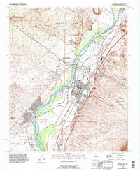
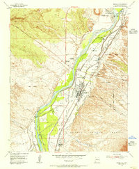 1954 Bernalillo1955 Print · USGSThe Rio Grande valley in the mid-fifties reveals a landscape of ancient land grants and complex irrigation networks. Genealogists and local historians can trace family-named sites and historic settlements like El Llanito, the Pilgrim Indian Mission Sch, and the Bernalillo Cem.3 unique versions available
 - 1954 Map of Bernalillo, 1957 Print
 1954 Bernalillo1957 Print · USGSThe Rio Grande valley in the mid-1950s reveals a complex landscape of ancestral pueblo grants and historic irrigation acequias. Researchers can trace the path of El Camino Real, locate the Pilgrim Indian Mission Sch, and find family-named landmarks like Loma Barbon.
 - 1958 Map of Albuquerque
 1958 Albuquerque1958 Print · USGSAlbuquerque and the surrounding high desert are captured here during a period of massive federal expansion and postwar growth. Researchers can trace the development of Kirtland Air Force Base, find ancestral homes in Pueblo de Santa Ana, or locate industrial sites like the Jackpile Mine.
 - 1960 Map of Los Griegos
 1960 Los Griegos1960 Print · USGSThe Rio Grande valley north of Albuquerque is captured here during a period of suburban growth into traditional grant lands. Researchers can trace the extensive irrigation network and find sites like St Joseph College, Los Poblanos Ranch, and the A T & S F RR.3 unique versions available
 - 1960 Map of Alameda
 1960 Alameda1960 Print · USGSThe Rio Grande valley north of Albuquerque shows a landscape of intensive irrigation and early suburban growth during the 1960s. Researchers can trace the historic Camino Real, locate family landmarks like San Ysidro Ch, or study the grounds of the Sandia View Academy.3 unique versions available
 - 1962 Map of Albuquerque
 1962 Albuquerque1962 Print · USGSAlbuquerque and the surrounding high desert are captured here in the early 1960s during a period of intense mineral and military growth. Genealogists and historians can locate early schools like the Pueblo Pintado School, major industrial sites like the Jackpile Mine, and the sprawling Kirtland Air Force Base.
 - 1963 Map of Albuquerque, 1965 Print
 1963 Albuquerque1965 Print · USGSMid-century New Mexico unfolds across this map, showcasing the intersection of ancient pueblos, modern military bases, and historic mining districts. Trace family roots and local history through the Ortiz Mine, Seven Lakes Trading Post, and Alameda.3 unique versions available
 - 1978 Map of Albuquerque, 1986 Print
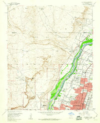
 1978 Albuquerque1986 Print · USGSGreater Albuquerque and the Rio Grande valley are captured here during a period of significant suburban expansion in the late seventies. Researchers can trace the early Subdivision Road Pattern near Rio Rancho and the historic footprints of Santa Ana Pueblo and Bernalillo.
 - 1983 Map of Albuquerque, 1984 Print
 1983 Albuquerque1984 Print · USGSCentral New Mexico in the early eighties shows a landscape where ancient pueblos and modern aerospace hubs meet. Trace the routes of the Atchison Topeka and Santa Fe RR or locate landmarks like Kirtland Air Force Base, Madrid, and the Sandia Mountains.
 - 1990 Map of Los Griegos, 1996 Print
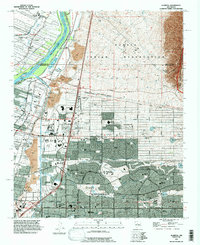
 1990 Los Griegos1996 Print · USGSThe Middle Rio Grande Valley in the early nineties shows a landscape of rapid suburban expansion meeting ancient heritage. Researchers can trace historic landmarks like Los Poblanos Ranch and the cultural sites of Petroglyph National Monument.
 - 1990 Map of Bernalillo, 1996 Print
 1990 Bernalillo1996 Print · USGSBernalillo and the Rio Grande valley are captured here in the early nineties during a period of suburban expansion alongside ancient pueblo lands. Trace irrigation history through the Bernalillo No 1 Lateral and find local landmarks like Carroll Sch or Sandia Pueblo.
 - 1990 Map of Loma Machete, 1996 Print
 1990 Loma Machete1996 Print · USGSSandoval County during a period of rapid suburban expansion shows the desert landscape being reshaped by new residential development. Trace the early street grids of Rio Rancho and Corrales alongside topographic landmarks like Picuda Peak and the Santa Ana Indian Reservation.
 - 1990 Map of Alameda, 1998 Print
 1990 Alameda1998 Print · USGSThe northern edge of the Albuquerque metro area and the Sandia Pueblo are captured here in the early nineties as suburban growth reached the river. Local historians can trace the irrigation systems like the Corrales Main Canal and find landmarks like Balloon Fiesta Park and Coronado Airport.
 - 2006 Map of Bernalillo, 2007 Print
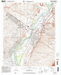 2006 Bernalillo2007 Print · USGSThe Middle Rio Grande Valley in the early 2000s shows a unique convergence of ancient Pueblo sites, Spanish land grants, and modern growth. Trace the historic Atchison Topeka and Santa Fe line or locate the Kuaua Ruins and Our Lady of Sorrows Ch.
 - 2006 Map of Alameda, 2007 Print
 2006 Alameda2007 Print · USGSNorth of Albuquerque in the mid-2000s, the Rio Grande valley transitions from historic grants to modern suburban neighborhoods. Genealogists and historians can trace local landmarks like San Carlos Cem, the International Balloon Museum, and the boundaries of the Sandia Pueblo Grant.
 - 2010 Map of Los Griegos, 2010 Print
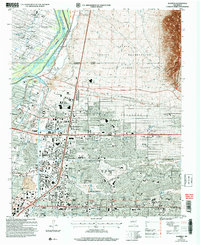
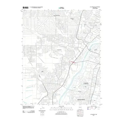 2010 Los Griegos2010 Print · USGSCovers Corrales, including Albuquerque, Rio Rancho, and other nearby areas
Showing maps 1-25 of 44
Top cities near Corrales
- Albuquerque historical maps
- Rio Rancho historical maps
- South Valley historical maps
- Bernalillo historical maps
- Los Ranchos de Albuquerque historical maps
- Paradise Hills historical maps
Frequently asked questions
- What are the different types of historical maps available for Corrales?
- What is the oldest map of Corrales?
- Where can I purchase historical maps of Corrales for my home or office?
- Where can I download high-res historical maps of Corrales?
- Are there historical topographic maps available for Corrales?
- Is there historical aerial imagery available for Corrales?
- Where are historical maps of Corrales sourced from?