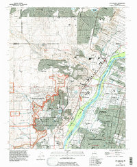
1990 Map of Los Griegos
USGS Topo · Published 1996About this map
Petroglyph National Monument dominates the western escarpment of this landscape, preserving cultural history along the volcanic basalt cliffs of the West Mesa. The terrain is defined by dramatic arroyos including Arroyo de las Calabacillas and Boca Negra Arroyo, which cut toward the fertile valley floor. In the east, the Rio Grande creates a lush corridor protected by the Rio Grande Valley State Park, contrasting sharply with the rapidly expanding residential grids of Albuquerque and Rio Rancho. The transition from historic agricultural roots is evident in the presence of Los Poblanos Ranch and the community of Los Griegos. Educational and social hubs such as the Southwestern Indian Polytechnical Institute and St Pius X High Sch are established alongside newer suburban developments like Paradise Hills, illustrating the late 20th-century growth of the Middle Rio Grande Valley.
Find a feature on this map
71 named features on this map. Tap any name to fly to it.
Don’t see what you’re looking for? This feature index may not catch every label — zoom into the map to look around manually.
Map Details
Editions of this 1990 Los Griegos Map
This is the sole edition of this map. No revisions or reprints were ever made.
Other maps of this area

1888 · Bernalillo
USGS Topo · 1:125,000

1889 · Albuquerque
USGS Topo · 1:125,000

1893 · Albuquerque
USGS Topo · 1:125,000

1934 · Alameda
USGS Topo · 1:24,000

1934 · West Albuquerque
USGS Topo · 1:24,000

1934 · Griegos
USGS Topo · 1:24,000

1934 · East Albuquerque
USGS Topo · 1:24,000

1938 · Albuquerque
USGS Topo · 1:62,500

1954 · Alameda
USGS Topo · 1:24,000

1954 · Volcano Ranch
USGS Topo · 1:24,000