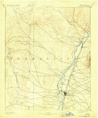
1889 Map of Albuquerque
USGS Topo · Published 1889About this map
Albuquerque emerges as a developing rail hub along the eastern bank of the Rio Grande in this late nineteenth-century survey. The arrival of the Atchison Topeka and Santa Fe Railroad has clearly reshaped the valley, running parallel to the river and connecting established riverfront settlements like Bernalillo, Alameda, and Corales. To the west, the landscape transitions toward the winding course of the Rio Puerco, where smaller outposts such as San Francisco and San Ygnacio are situated.
Find a feature on this map
14 named features on this map. Tap any name to fly to it.
Don’t see what you’re looking for? This feature index may not catch every label — zoom into the map to look around manually.
Map Details
Editions of this 1889 Albuquerque Map
This is the sole edition of this map. No revisions or reprints were ever made.
Historical Maps of Albuquerque Through Time
8 maps found