1960s Maps of Corrales, New Mexico
Explore 4 historic maps of Corrales from the 1960s. These maps offer a rare glimpse into what life looked like during the 1960s — showing old roads, neighborhoods, homes, and landmarks that have changed or disappeared over time.
Whether you're researching your family's past, planning a metal detecting trip, or studying how Corrales's landscape evolved across the 1960s, these high-resolution maps are a powerful tool for exploring the history of this region.
- Focus on a specific era: All maps on this page are from the 1960s, giving you a focused view of this time period.
- See what’s changed: Compare century-old streets, trails, and buildings to today's modern landscape using overlays and satellite layers.
- Research with precision: Use these maps for genealogy, historical research, land use analysis, or educational projects.
- View, download, or print: Maps are fully viewable online in high resolution, and can be downloaded or printed for your own records.
Start exploring Corrales's history through authentic maps from the 1960s. This is your window into the past.
Corrales, NM maps
(4)- 1960 Map of Los Griegos
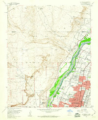 1960 Los Griegos1960 Print · USGSThe Rio Grande valley north of Albuquerque is captured here during a period of suburban growth into traditional grant lands. Researchers can trace the extensive irrigation network and find sites like St Joseph College, Los Poblanos Ranch, and the A T & S F RR.3 unique versions available
 - 1960 Map of Alameda
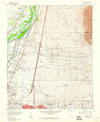 1960 Alameda1960 Print · USGSThe Rio Grande valley north of Albuquerque shows a landscape of intensive irrigation and early suburban growth during the 1960s. Researchers can trace the historic Camino Real, locate family landmarks like San Ysidro Ch, or study the grounds of the Sandia View Academy.3 unique versions available
 - 1962 Map of Albuquerque
 1962 Albuquerque1962 Print · USGSAlbuquerque and the surrounding high desert are captured here in the early 1960s during a period of intense mineral and military growth. Genealogists and historians can locate early schools like the Pueblo Pintado School, major industrial sites like the Jackpile Mine, and the sprawling Kirtland Air Force Base.
 - 1963 Map of Albuquerque, 1965 Print
 1963 Albuquerque1965 Print · USGSMid-century New Mexico unfolds across this map, showcasing the intersection of ancient pueblos, modern military bases, and historic mining districts. Trace family roots and local history through the Ortiz Mine, Seven Lakes Trading Post, and Alameda.3 unique versions available
End of results
Showing maps 1-4 of 4
Top cities near Corrales
- Albuquerque historical maps
- Rio Rancho historical maps
- South Valley historical maps
- Bernalillo historical maps
- Los Ranchos de Albuquerque historical maps
- Paradise Hills historical maps
Frequently asked questions
- What are the different types of historical maps available for Corrales?
- What is the oldest map of Corrales?
- Where can I purchase historical maps of Corrales for my home or office?
- Where can I download high-res historical maps of Corrales?
- Are there historical topographic maps available for Corrales?
- Is there historical aerial imagery available for Corrales?
- Where are historical maps of Corrales sourced from?