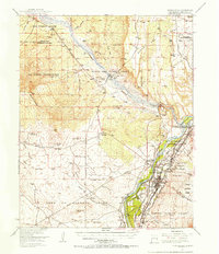
1954 Map of Bernalillo
USGS Topo · Published 1957About this map
The Rio Grande and Jemez River define the intricate boundary-work of this mid-century landscape, where massive historic land grants intersect with the valley's ancient agricultural infrastructure. This 1954 survey captures a moment when traditional water systems like the Bernalillo Acequia and Albuquerque Main Canal supported the communities of Bernalillo and Corrales. The map meticulously details the ancestral lands of the Santa Ana Pueblo Grant, Zia Pueblo Grant, and Sandia Pueblo Grant, showing the interplay of native settlements and mission-led education at sites like the Our Lady of Sorrows Sch and the Pilgrim Indian Mission Sch. Beyond the river valley, the terrain transitions to high mesas and arroyos, such as Arroyo de los Montoyas, marked by the industrial footprints of an Inactive Strip Mine and the engineering of the Jemez Canyon Dam.
Find a feature on this map
58 named features on this map. Tap any name to fly to it.
Don’t see what you’re looking for? This feature index may not catch every label — zoom into the map to look around manually.
Map Details
Editions of this 1954 Bernalillo Map
This is the sole edition of this map. No revisions or reprints were ever made.
Other maps of this area

1888 · Bernalillo
USGS Topo · 1:125,000

1889 · Albuquerque
USGS Topo · 1:125,000

1890 · Jemes
USGS Topo · 1:125,000

1892 · San Pedro
USGS Topo · 1:125,000

1892 · Jemes
USGS Topo · 1:125,000

1892 · Santa Clara
USGS Topo · 1:125,000

1893 · Albuquerque
USGS Topo · 1:125,000

1934 · Alameda
USGS Topo · 1:24,000

1934 · Griegos
USGS Topo · 1:24,000

1938 · Albuquerque
USGS Topo · 1:62,500