1960s Maps of Jemez Pueblo, New Mexico
Explore 4 historic maps of Jemez Pueblo from the 1960s. These maps offer a rare glimpse into what life looked like during the 1960s — showing old roads, neighborhoods, homes, and landmarks that have changed or disappeared over time.
Whether you're researching your family's past, planning a metal detecting trip, or studying how Jemez Pueblo's landscape evolved across the 1960s, these high-resolution maps are a powerful tool for exploring the history of this region.
- Focus on a specific era: All maps on this page are from the 1960s, giving you a focused view of this time period.
- See what’s changed: Compare century-old streets, trails, and buildings to today's modern landscape using overlays and satellite layers.
- Research with precision: Use these maps for genealogy, historical research, land use analysis, or educational projects.
- View, download, or print: Maps are fully viewable online in high resolution, and can be downloaded or printed for your own records.
Start exploring Jemez Pueblo's history through authentic maps from the 1960s. This is your window into the past.
Jemez Pueblo, NM maps
(4)- 1962 Map of Albuquerque
 1962 Albuquerque1962 Print · USGSAlbuquerque and the surrounding high desert are captured here in the early 1960s during a period of intense mineral and military growth. Genealogists and historians can locate early schools like the Pueblo Pintado School, major industrial sites like the Jackpile Mine, and the sprawling Kirtland Air Force Base.
 - 1963 Map of Albuquerque, 1965 Print
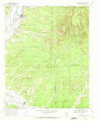
 1963 Albuquerque1965 Print · USGSMid-century New Mexico unfolds across this map, showcasing the intersection of ancient pueblos, modern military bases, and historic mining districts. Trace family roots and local history through the Ortiz Mine, Seven Lakes Trading Post, and Alameda.3 unique versions available
 - 1969 Map of San Ysidro, 1972 Print
 1969 San Ysidro1972 Print · USGSSandoval County at the end of the sixties reveals a landscape shaped by tribal lands and traditional water rights. Trace the path of the Old Railroad Grade and locate historical landmarks like the Mexican Ditch, Zia Pueblo, and White Mesa.2 unique versions available
 - 1969 Map of Jemez Pueblo, 1972 Print
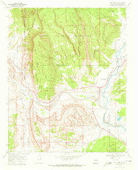
 1969 Jemez Pueblo1972 Print · USGSTraditional Pueblo lands and intricate irrigation networks define this Sandoval County territory during the late sixties. Researchers can trace ancestral boundaries and water features like Jemez Pueblo, the Zia North Side Canal, and Ojo Chamisa.2 unique versions available
End of results
Showing maps 1-4 of 4
Top cities near Jemez Pueblo
- Rio Rancho historical maps
- Eastern Navajo Agency historical maps
- Jemez Springs historical maps
- San Ysidro historical maps
Top neighborhoods of Jemez Pueblo
Frequently asked questions
- What are the different types of historical maps available for Jemez Pueblo?
- What is the oldest map of Jemez Pueblo?
- Where can I purchase historical maps of Jemez Pueblo for my home or office?
- Where can I download high-res historical maps of Jemez Pueblo?
- Are there historical topographic maps available for Jemez Pueblo?
- Is there historical aerial imagery available for Jemez Pueblo?
- Where are historical maps of Jemez Pueblo sourced from?