1900s (20th Century) Maps of Engle, New Mexico
Explore 6 historic maps of Engle from the 1900s (20th Century). These maps offer a rare glimpse into what life looked like during the 1900s — showing old roads, neighborhoods, homes, and landmarks that have changed or disappeared over time.
Whether you're researching your family's past, planning a metal detecting trip, or studying how Engle's landscape evolved across the 1900s, these high-resolution maps are a powerful tool for exploring the history of this region.
- Focus on a specific era: All maps on this page are from the 1900s, giving you a focused view of this time period.
- See what’s changed: Compare century-old streets, trails, and buildings to today's modern landscape using overlays and satellite layers.
- Research with precision: Use these maps for genealogy, historical research, land use analysis, or educational projects.
- View, download, or print: Maps are fully viewable online in high resolution, and can be downloaded or printed for your own records.
Start exploring Engle's history through authentic maps from the 1900s. This is your window into the past.
Engle, NM maps
(6)- 1954 Map of Tularosa, 1963 Print
 1954 Tularosa1963 Print · USGSSouth-central New Mexico in the early fifties shows a landscape of desert basins and high peaks under heavy military and water-reclamation use. Trace the path of the Atchison Topeka and Santa Fe Railway past San Marcial and into the massive White Sands Proving Ground.4 unique versions available
 - 1958 Map of Tularosa
 1958 Tularosa1958 Print · USGSSouthern New Mexico in the late fifties shows a landscape of military expansion and deep-rooted river settlements. Trace family history in Truth or Consequences or locate the ruins of San Marcial and the remote Dusty Post Office.2 unique versions available
 - 1959 Map of Engle, 1961 Print
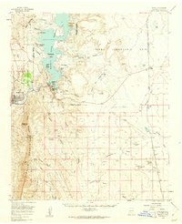 1959 Engle1961 Print · USGSSierra County in the late fifties showcases the rise of the Elephant Butte Reservoir alongside the traditional ranching lands of the Jornada del Muerto. Researchers can trace the Atchison Topeka and Santa Fe line to Engle, locate Fort Mc Rae (Historical Site), and find family-named sites like Mc Clennon Ranch.2 unique versions available
 - 1979 Map of Truth or Consequences
 1979 Truth or Consequences1979 Print · USGSSierra County in the late seventies is a landscape of massive reservoirs and remote mining districts. Researchers can trace the Rio Grande corridor from Truth or Consequences past historic outposts like Winston, Chloride, and the Republic Mine.2 unique versions available
 - 1985 Map of Engle
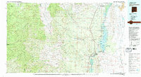
 1985 Engle1985 Print · USGSSierra County's high desert landscape comes into focus during the mid-1980s, centered on the ranching community of Engle. Researchers can trace the path of the Old RR Grade and locate specific landmarks like Engle Lake and a solitary Grave.
 - 1996 Map of Engle, 2002 Print
 1996 Engle2002 Print · USGSSierra County's arid basin and range topography is captured here during the late twentieth century. Genealogists and historians can locate the community of Engle, trace the Old RR Grade, and find individual markers like a Cem or a lone Grave.
End of results
Showing maps 1-6 of 6
Top cities near Engle
Frequently asked questions
- What are the different types of historical maps available for Engle?
- What is the oldest map of Engle?
- Where can I purchase historical maps of Engle for my home or office?
- Where can I download high-res historical maps of Engle?
- Are there historical topographic maps available for Engle?
- Is there historical aerial imagery available for Engle?
- Where are historical maps of Engle sourced from?