1980s Maps of Kingston, New Mexico
Explore 2 historic maps of Kingston from the 1980s. These maps offer a rare glimpse into what life looked like during the 1980s — showing old roads, neighborhoods, homes, and landmarks that have changed or disappeared over time.
Whether you're researching your family's past, planning a metal detecting trip, or studying how Kingston's landscape evolved across the 1980s, these high-resolution maps are a powerful tool for exploring the history of this region.
- Focus on a specific era: All maps on this page are from the 1980s, giving you a focused view of this time period.
- See what’s changed: Compare century-old streets, trails, and buildings to today's modern landscape using overlays and satellite layers.
- Research with precision: Use these maps for genealogy, historical research, land use analysis, or educational projects.
- View, download, or print: Maps are fully viewable online in high resolution, and can be downloaded or printed for your own records.
Start exploring Kingston's history through authentic maps from the 1980s. This is your window into the past.
Kingston, NM maps
(2)- 1982 Map of Hatch
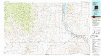 1982 Hatch1982 Print · USGSThe Rio Grande valley and the rugged Mimbres Mountains meet in this early 1980s overview of southern New Mexico. Researchers can trace the path of the Atchison Topeka and Santa Fe railroad or locate historic mining hubs like Hillsboro and Lake Valley.
 - 1985 Map of Kingston
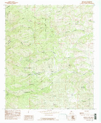 1985 Kingston1985 Print · USGSKingston was a vital node in the high country of Sierra County during the mid-eighties, surrounded by the protected wilds of the Gila. Researchers can trace the legacy of mining and early settlement through sites like the USLM No 3, several Mine locations, and the quiet clearing at Trujillo Park.
End of results
Showing maps 1-2 of 2
Frequently asked questions
- What are the different types of historical maps available for Kingston?
- What is the oldest map of Kingston?
- Where can I purchase historical maps of Kingston for my home or office?
- Where can I download high-res historical maps of Kingston?
- Are there historical topographic maps available for Kingston?
- Is there historical aerial imagery available for Kingston?
- Where are historical maps of Kingston sourced from?