1900s (20th Century) Maps of Moly, New Mexico
Explore 5 historic maps of Moly from the 1900s (20th Century). These maps offer a rare glimpse into what life looked like during the 1900s — showing old roads, neighborhoods, homes, and landmarks that have changed or disappeared over time.
Whether you're researching your family's past, planning a metal detecting trip, or studying how Moly's landscape evolved across the 1900s, these high-resolution maps are a powerful tool for exploring the history of this region.
- Focus on a specific era: All maps on this page are from the 1900s, giving you a focused view of this time period.
- See what’s changed: Compare century-old streets, trails, and buildings to today's modern landscape using overlays and satellite layers.
- Research with precision: Use these maps for genealogy, historical research, land use analysis, or educational projects.
- View, download, or print: Maps are fully viewable online in high resolution, and can be downloaded or printed for your own records.
Start exploring Moly's history through authentic maps from the 1900s. This is your window into the past.
Moly, NM maps
(5)- 1954 Map of Raton, 1963 Print
 1954 Raton1963 Print · USGSNorthern New Mexico's high-country and plains are documented here in the early sixties, showing the region's ranching and mining infrastructure. Trace the legacy of the Maxwell Land Grant, locate remote rural sites like Tafoya School, and follow the Atchison Topeka and Santa Fe Railway through the heart of Raton.3 unique versions available
 - 1958 Map of Raton
 1958 Raton1958 Print · USGSNorthern New Mexico and the Colorado borderlands are mapped here in the late fifties, showcasing a landscape of high peaks and historic land grants. Genealogists and historians can trace families across Picuris Pueblo, find old schoolhouses like Piedra Lumbre School, or follow the Atchison Topeka and Santa Fe rail line.3 unique versions available
 - 1963 Map of Red River, 1967 Print
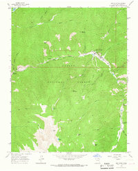 1963 Red River1967 Print · USGSRed River and the surrounding Carson National Forest come into focus in the 1960s, showing a transition from mining roots to mountain tourism. You can trace the development of the Ski Lift and Mallette Campground alongside industrial sites like the Moly Tailings Ponds.2 unique versions available
 - 1982 Map of Wheeler Peak, 1983 Print
 1982 Wheeler Peak1983 Print · USGSNorthern New Mexico in the early eighties shows a high-altitude landscape of historic mining camps and massive land grants. Researchers can trace the Old Railroad Grade near Elizabethtown or locate remote sites like the French-Henry Mine and Vermejo Park.
 - 1995 Map of Red River, 1997 Print
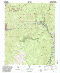 1995 Red River1997 Print · USGSThe high mountain town of Red River is shown in the mid-1990s during a period of transition between its mining roots and its growth as a ski destination. Researchers can trace the industrial footprint of the Moly Mine and Open Pit Mine or find recreational landmarks like St Edwin Chapel and the Red River Ski Area.
End of results
Showing maps 1-5 of 5
Top cities near Moly
- Questa historical maps
- Red River historical maps
- Eagle Nest historical maps
- Taos Ski Valley historical maps
Frequently asked questions
- What are the different types of historical maps available for Moly?
- What is the oldest map of Moly?
- Where can I purchase historical maps of Moly for my home or office?
- Where can I download high-res historical maps of Moly?
- Are there historical topographic maps available for Moly?
- Is there historical aerial imagery available for Moly?
- Where are historical maps of Moly sourced from?