1900s (20th Century) Maps of Taos, New Mexico
Explore 7 historic maps of Taos from the 1900s (20th Century). These maps offer a rare glimpse into what life looked like during the 1900s — showing old roads, neighborhoods, homes, and landmarks that have changed or disappeared over time.
Whether you're researching your family's past, planning a metal detecting trip, or studying how Taos's landscape evolved across the 1900s, these high-resolution maps are a powerful tool for exploring the history of this region.
- Focus on a specific era: All maps on this page are from the 1900s, giving you a focused view of this time period.
- See what’s changed: Compare century-old streets, trails, and buildings to today's modern landscape using overlays and satellite layers.
- Research with precision: Use these maps for genealogy, historical research, land use analysis, or educational projects.
- View, download, or print: Maps are fully viewable online in high resolution, and can be downloaded or printed for your own records.
Start exploring Taos's history through authentic maps from the 1900s. This is your window into the past.
Taos, NM maps
(7)- 1954 Map of Raton, 1963 Print
 1954 Raton1963 Print · USGSNorthern New Mexico's high-country and plains are documented here in the early sixties, showing the region's ranching and mining infrastructure. Trace the legacy of the Maxwell Land Grant, locate remote rural sites like Tafoya School, and follow the Atchison Topeka and Santa Fe Railway through the heart of Raton.3 unique versions available
 - 1958 Map of Raton
 1958 Raton1958 Print · USGSNorthern New Mexico and the Colorado borderlands are mapped here in the late fifties, showcasing a landscape of high peaks and historic land grants. Genealogists and historians can trace families across Picuris Pueblo, find old schoolhouses like Piedra Lumbre School, or follow the Atchison Topeka and Santa Fe rail line.3 unique versions available
 - 1964 Map of Taos, 1966 Print
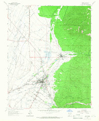 1964 Taos1966 Print · USGSTaos and its surrounding pueblo lands are shown in the early sixties during a period of steady growth and cultural preservation. Genealogists and historians can trace the intricate network of irrigation ditches and family cemeteries like Graham Cem and Colonia Cem.2 unique versions available
 - 1964 Map of Ranchos De Taos, 1967 Print
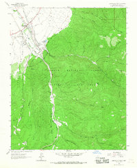 1964 Ranchos De Taos1967 Print · USGSTaos County in the mid-1960s reveals a landscape of high-altitude mountain grants and traditional valley acequias. Genealogists and historians can trace family locations near St Francis Ch, Hart Cem, and the old grounds of Ft Burgwin along the Rio Grande del Rancho.
 - 1983 Map of Taos
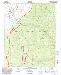
 1983 Taos1983 Print · USGSNorthern New Mexico's high-country heritage is on full display in the early eighties, from the deep river canyons to the highest alpine peaks. Genealogists and historians can trace traditional land-grant settlements like Las Trampas, Truchas, and the historic Taos Pueblo.2 unique versions available
 - 1995 Map of Ranchos De Taos, 1997 Print
 1995 Ranchos De Taos1997 Print · USGSTraditional Spanish land grants and irrigation acequias define this high-altitude landscape near the end of the century. Genealogists and historians can trace family sites near Ranchos De Taos, St Francis Cem, and the Talpa Reservoir.
 - 1995 Map of Taos, 1998 Print
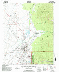 1995 Taos1998 Print · USGSTaos and the surrounding pueblo lands appear in the mid-nineties as the community expanded along its historic acequias. Researchers can trace land grant boundaries and locate numerous family burial sites including Kit Carson Cem, La Loma Cem, and the Colonias Cem.
End of results
Showing maps 1-7 of 7
Top cities near Taos
Frequently asked questions
- What are the different types of historical maps available for Taos?
- What is the oldest map of Taos?
- Where can I purchase historical maps of Taos for my home or office?
- Where can I download high-res historical maps of Taos?
- Are there historical topographic maps available for Taos?
- Is there historical aerial imagery available for Taos?
- Where are historical maps of Taos sourced from?