1970s Maps of Guilderland, New York
Explore 1 historic maps of Guilderland from the 1970s. These maps offer a rare glimpse into what life looked like during the 1970s — showing old roads, neighborhoods, homes, and landmarks that have changed or disappeared over time.
Whether you're researching your family's past, planning a metal detecting trip, or studying how Guilderland's landscape evolved across the 1970s, these high-resolution maps are a powerful tool for exploring the history of this region.
- Focus on a specific era: All maps on this page are from the 1970s, giving you a focused view of this time period.
- See what’s changed: Compare century-old streets, trails, and buildings to today's modern landscape using overlays and satellite layers.
- Research with precision: Use these maps for genealogy, historical research, land use analysis, or educational projects.
- View, download, or print: Maps are fully viewable online in high resolution, and can be downloaded or printed for your own records.
Start exploring Guilderland's history through authentic maps from the 1970s. This is your window into the past.
Guilderland, NY maps
(1)- 1978 Map of Albany, 1982 Print
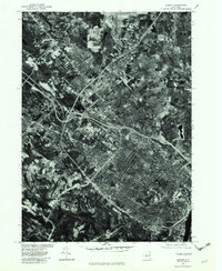 1978 Albany1982 Print · USGSThe capital region comes into sharp focus in the late seventies through this detailed orthophotoquad. Trace the development of residential neighborhoods and transit networks from Albany out to Colonie, Delmar, and Loudonville.
End of results
Showing maps 1-1 of 1
Top cities near Guilderland
- Albany historical maps
- Colonie historical maps
- Schenectady historical maps
- Clifton Park historical maps
- Bethlehem historical maps
- Rotterdam historical maps
See more
Top neighborhoods of Guilderland
- Meadowdale historical maps
- Dunnsville historical maps
- McKownville historical maps
- Parkers Corners historical maps
- Guilderland Center historical maps
- North Bethlehem historical maps
See more
Frequently asked questions
- What are the different types of historical maps available for Guilderland?
- What is the oldest map of Guilderland?
- Where can I purchase historical maps of Guilderland for my home or office?
- Where can I download high-res historical maps of Guilderland?
- Are there historical topographic maps available for Guilderland?
- Is there historical aerial imagery available for Guilderland?
- Where are historical maps of Guilderland sourced from?