1940s Maps of New Scotland, New York
Explore 7 historic maps of New Scotland from the 1940s. These maps offer a rare glimpse into what life looked like during the 1940s — showing old roads, neighborhoods, homes, and landmarks that have changed or disappeared over time.
Whether you're researching your family's past, planning a metal detecting trip, or studying how New Scotland's landscape evolved across the 1940s, these high-resolution maps are a powerful tool for exploring the history of this region.
- Focus on a specific era: All maps on this page are from the 1940s, giving you a focused view of this time period.
- See what’s changed: Compare century-old streets, trails, and buildings to today's modern landscape using overlays and satellite layers.
- Research with precision: Use these maps for genealogy, historical research, land use analysis, or educational projects.
- View, download, or print: Maps are fully viewable online in high resolution, and can be downloaded or printed for your own records.
Start exploring New Scotland's history through authentic maps from the 1940s. This is your window into the past.
New Scotland, NY maps
(7)- 1943 Map of Westerlo, 1958 Print
 1943 Westerlo1958 Print · USGSAlbany County's upland terrain is captured here during the mid-century, showcasing the rural road networks and hill-country settlements of the Helderbergs. Researchers can trace genealogical roots at Reidsville Cem or locate vanished landmarks like Van Leuvens Sch and Bramans Corners.3 unique versions available
 - 1944 Map of Altamont, 1959 Print
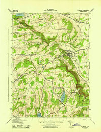
 1944 Altamont1959 Print · USGSAlbany County's steep ridges and valley settlements are captured here during the mid-1940s. Trace old family plots at Severson Cem, visit the Lasalette Seminary, or explore the terrain around Indian Ladder.4 unique versions available
 - 1946 Map of Westerlo
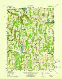 1946 Westerlo1946 Print · USGSAlbany County's rural uplands are captured here in the mid-1940s, showing a landscape of high ridges and scattered crossroads settlements. Genealogists can trace family names at Westerlo Cem or locate old schoolhouse sites like Van Leuvans Sch and School No 11.
 - 1946 Map of Altamont
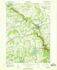
 1946 Altamont1946 Print · USGSThe Helderberg Escarpment rises sharply over the village of Altamont in this mid-forties survey of Albany County. Family historians can trace rural roots at Ostrander Cem or locate early landmarks like Indian Ladder and the Lasalette Seminary.
 - 1947 Map of Albany, 1965 Print
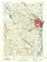 1947 Albany1965 Print · USGSThe Albany capital region is captured here shortly after the war, showing the city's transition into suburban Delmar and Loudonville. Researchers can trace the massive Voorheesville Army Sub Depot, the Albany Airport, and old landmarks like Graceland Cemetery.
 - 1948 Map of Albany, 1951 Print
 1948 Albany1951 Print · USGSThe Hudson and Connecticut River valleys are captured here in the late 1940s, showing the vital rail and water corridors of the Northeast. You can trace the Boston and Maine tracks past Mt Greylock or locate early settlements like Great Barrington and Bennington.
 - 1948 Map of Binghamton, 1980 Print
 1948 Binghamton1980 Print · USGSCentral New York and the Southern Tier thrive in the late 1940s as a hub of rail traffic and mountain industry. Researchers can trace historic transit lines like the Erie Railroad through Binghamton or find old valley settlements near Oneonta and Delhi.
End of results
Showing maps 1-7 of 7
Top cities near New Scotland
- Albany historical maps
- Colonie historical maps
- Schenectady historical maps
- Clifton Park historical maps
- Guilderland historical maps
- Bethlehem historical maps
See more
Top neighborhoods of New Scotland
- Feura Bush historical maps
- New Salem historical maps
- Tarrytown historical maps
- Clarksville historical maps
- Unionville historical maps
- Voorheesville historical maps
Frequently asked questions
- What are the different types of historical maps available for New Scotland?
- What is the oldest map of New Scotland?
- Where can I purchase historical maps of New Scotland for my home or office?
- Where can I download high-res historical maps of New Scotland?
- Are there historical topographic maps available for New Scotland?
- Is there historical aerial imagery available for New Scotland?
- Where are historical maps of New Scotland sourced from?