1960s Maps of Wellsville, New York
Explore 11 historic maps of Wellsville from the 1960s. These maps offer a rare glimpse into what life looked like during the 1960s — showing old roads, neighborhoods, homes, and landmarks that have changed or disappeared over time.
Whether you're researching your family's past, planning a metal detecting trip, or studying how Wellsville's landscape evolved across the 1960s, these high-resolution maps are a powerful tool for exploring the history of this region.
- Focus on a specific era: All maps on this page are from the 1960s, giving you a focused view of this time period.
- See what’s changed: Compare century-old streets, trails, and buildings to today's modern landscape using overlays and satellite layers.
- Research with precision: Use these maps for genealogy, historical research, land use analysis, or educational projects.
- View, download, or print: Maps are fully viewable online in high resolution, and can be downloaded or printed for your own records.
Start exploring Wellsville's history through authentic maps from the 1960s. This is your window into the past.
Wellsville, NY maps
(11)- 1960 Map of Buffalo
 1960 Buffalo1960 Print · USGSWestern New York and the Niagara Peninsula thrive during the mid-twentieth century industrial peak. Genealogists and historians can trace family-named points and early settlements from Dunkirk Light to the Allegany Indian Reservation.
 - 1962 Map of Elmira, 1969 Print
 1962 Elmira1969 Print · USGSThe Finger Lakes region and Southern Tier are captured here during a period of industrial maturity and highway expansion. Researchers can trace the path of the Erie Canal, the footprint of the Seneca Army Depot, and legacy rail lines through Elmira and Ithaca.4 unique versions available
 - 1962 Map of Buffalo, 1980 Print
 1962 Buffalo1980 Print · USGSThe Niagara Frontier and Western New York are captured here in the early sixties, showing the vital industrial and maritime nexus between the U.S. and Canada. Researchers can trace the path of the Welland Canal, locate the Allegany Indian Reservation, or find family sites near Chautauqua Lake.2 unique versions available
 - 1965 Map of Elmira
 1965 Elmira1965 Print · USGSThe Finger Lakes and Southern Tier regions are captured in the mid-sixties, showcasing a landscape of deep glacial valleys and heavy rail infrastructure. Trace old railroad corridors like the Pennsylvania RR or visit landmarks like Letchworth State Park and the Seneca Army Depot.
 - 1965 Map of Whitesville, 1966 Print
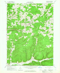
 1965 Whitesville1966 Print · USGSAllegany County near the Pennsylvania border is shown here as a center of energy production in the mid-sixties. Genealogists and researchers can locate family-named features like Beech Hill Cem and trace old crossroads at Whitesville, Hallsport, and Spring Mills.2 unique versions available
 - 1965 Map of Wellsville North, 1966 Print
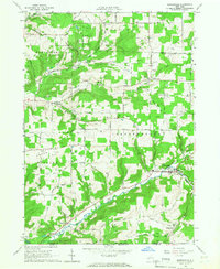
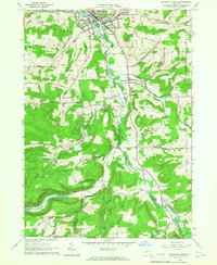
 1965 Wellsville North1966 Print · USGSThe Genesee River valley in the mid-1960s reveals a landscape shaped by the rail-and-river economy and early energy extraction. Genealogists and local historians can trace family-named ridges like Oak Hill or locate landmarks such as St Josephs Ch, Rogers Cem, and the village of Scio.3 unique versions available
 - 1965 Map of Allentown, 1966 Print
 1965 Allentown1966 Print · USGSAllegany County during the mid-1960s reveals a landscape defined by its petroleum heritage and deep valley settlements. Researchers can trace the extensive network of Oil Wells across Bow Ridge, find family plots at Dimmick Cem, and locate the small communities of Allentown and Petrolia.
 - 1965 Map of Belmont, 1966 Print
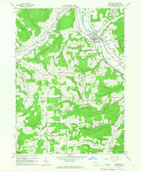 1965 Belmont1966 Print · USGSAllegany County's river valleys and oil fields come into focus in the mid-1960s as the rail-and-river network of the Genesee continues to shape local life. Genealogists and historians can trace family-named sites across the hills, from Sortore Cem and Higgins to the Erie-Lackawanna rail lines.2 unique versions available
 - 1965 Map of Wellsville South, 1967 Print
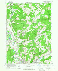
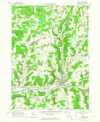
 1965 Wellsville South1967 Print · USGSThe Genesee River valley in the mid-sixties reveals a landscape of oil production and rural New York life. Genealogists can trace family landmarks like Johnson Cem or follow the Erie-Lackawanna rail line through Wellsville and Stannards.2 unique versions available
 - 1965 Map of Andover, 1967 Print
 1965 Andover1967 Print · USGSAllegany County in the mid-sixties reveals a landscape of railroad heritage and timber conservation near the village of Andover. Genealogists can trace family names at St Johns Cem and East Valley Cem or locate industrial sites like the many southern Oil Wells.2 unique versions available
 - 1967 Map of Buffalo
 1967 Buffalo1967 Print · USGSWestern New York and the Lake Erie shoreline are shown here during the mid-1960s industrial peak. Researchers can trace the massive rail networks of the Erie Railroad, locate the Cattaraugus Indian Reservation, or find historic sites like Fort Erie.
End of results
Showing maps 1-11 of 11
Top cities near Wellsville
- Alfred historical maps
- Wellsville historical maps
- Hornellsville historical maps
- Alfred historical maps
- Caneadea historical maps
- Amity historical maps
See more
Top neighborhoods of Wellsville
Frequently asked questions
- What are the different types of historical maps available for Wellsville?
- What is the oldest map of Wellsville?
- Where can I purchase historical maps of Wellsville for my home or office?
- Where can I download high-res historical maps of Wellsville?
- Are there historical topographic maps available for Wellsville?
- Is there historical aerial imagery available for Wellsville?
- Where are historical maps of Wellsville sourced from?