1950s Maps of Broome County, New York
Explore 23 historic maps of Broome County from the 1950s. These maps offer a rare glimpse into what life looked like during the 1950s — showing old roads, neighborhoods, homes, and landmarks that have changed or disappeared over time.
Whether you're researching your family's past, planning a metal detecting trip, or studying how Broome County's landscape evolved across the 1950s, these high-resolution maps are a powerful tool for exploring the history of this region.
- Focus on a specific era: All maps on this page are from the 1950s, giving you a focused view of this time period.
- See what’s changed: Compare century-old streets, trails, and buildings to today's modern landscape using overlays and satellite layers.
- Research with precision: Use these maps for genealogy, historical research, land use analysis, or educational projects.
- View, download, or print: Maps are fully viewable online in high resolution, and can be downloaded or printed for your own records.
Start exploring Broome County's history through authentic maps from the 1950s. This is your window into the past.
Broome County, NY maps
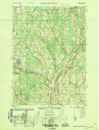
(23)- 1950 Map of Elmira
 1950 Elmira1950 Print · USGSThe Finger Lakes region thrived in the late 1940s as a hub of industry and transport. Trace family roots and vanished landmarks near Seneca Lake or explore the rail lines of the Erie RR and the sprawling Seneca Ordnance Depot.2 unique versions available
 - 1950 Map of Greene
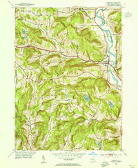
 1950 Greene1950 Print · USGSThe Chenango River valley in the years after the war shows a landscape of rail-connected villages and historic turnpikes. Genealogists can locate family burial sites at Sylvan Lawn Cem and Horton Cem or trace the path of the Catskill Turnpike.
 - 1950 Map of Binghamton
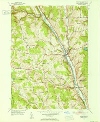
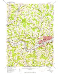
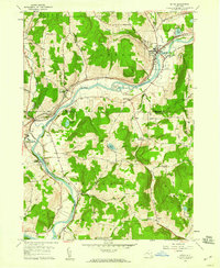
 1950 Binghamton1950 Print · USGSBinghamton and the surrounding Southern Tier are shown in the mid-century era, highlighting the intricate rail and river networks that drove local industry. Researchers can trace the path of the Erie Railroad and locate landmarks from Otsego Lake to Sidney Mountain.2 unique versions available
 - 1950 Map of Smithville Flats
 1950 Smithville Flats1950 Print · USGSMid-century Chenango County remains a landscape of dairy farms and small hamlets before modern development altered the rural character. Trace ancestral roots at Westview Cem, locate vanished schoolhouses like School No 1, and explore the banks of Genegantslet Creek.
 - 1950 Map of Chenango Forks, 1951 Print
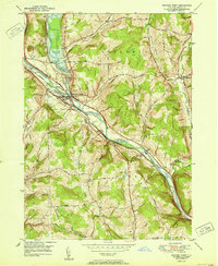
 1950 Chenango Forks1951 Print · USGSThe river valleys and rail lines north of Binghamton converge here at the start of the 1950s. Genealogists and local historians can trace the rural school system from School No 29 to School No 5, or follow the rail-era growth of Port Crane and Sanitaria Springs.
 - 1950 Map of Marathon, 1952 Print
 1950 Marathon1952 Print · USGSMid-century Cortland County comes to life along the river and rail lines of the Tioughnioga valley. Researchers can trace family roots through upland landmarks like Lapeer Church, Hunts Corners, and the tracks of the Delaware Lackawanna and Western.5 unique versions available
 - 1950 Map of Scranton, 1952 Print
 1950 Scranton1952 Print · USGSMid-century Northeast Pennsylvania and the Hudson Valley come alive in this survey of the tri-state region. Genealogists and historians can trace the dense rail networks of the Erie RR and DL&W RR between industrial hubs like Scranton and Wilkes-Barre.
 - 1951 Map of Harford
 1951 Harford1951 Print · USGSCortland County's southern hills and railroad hamlets are captured here at mid-century, just as the local rural economy was shifting. Genealogists and historians can locate the Birthplace of John D Rockefeller and trace the Lehigh Valley rail line through Harford Mills.
 - 1951 Map of Willet
 1951 Willet1951 Print · USGSThe Otselic River valley in Cortland and Broome counties comes alive in this mid-century survey. Genealogists and local historians can trace the foundations of Upper Lisle and Texas Valley or locate family plots at Green Cem.
 - 1951 Map of Whitney Point
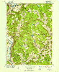
 1951 Whitney Point1951 Print · USGSBroome County villages and valley farms appear here at the midpoint of the century, following the completion of major flood control projects. Researchers can trace historic cemeteries like St Patricks Cem and the route of the Delaware Lackawanna and Western RR through Lisle and Whitney Point.
 - 1951 Map of Lisle
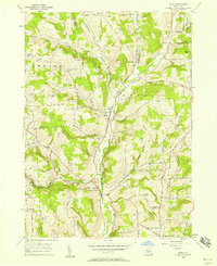
 1951 Lisle1951 Print · USGSThe Broome County hills and the Tioughnioga River valley are captured here in the early fifties, showing a landscape of small hamlets and high ridges. Researchers can trace historic routes like the Catskill Turnpike and locate family landmarks in Ketchumville, Glen Aubrey, and Center Lisle.
 - 1952 Map of Gulf Summit, 1954 Print
 1952 Gulf Summit1954 Print · USGSBroome County was a landscape of steep ridges and critical railway passes in the mid-twentieth century. Genealogists and rail historians can trace the paths of the ERIE and Delaware and Hudson railroads past Gulf Summit and Edwards Cem.4 unique versions available
 - 1952 Map of Windsor, 1955 Print
 1952 Windsor1955 Print · USGSThe Susquehanna River valley in the early fifties shows a landscape of established hill-country hamlets and riverfront industry. Genealogists and local researchers can trace family landmarks at Riverside Cem, the settlement at Lester, and the rural Central Sch.3 unique versions available
 - 1953 Map of Scranton
 1953 Scranton1953 Print · USGSNortheastern Pennsylvania and the Catskills are shown in great detail during the early fifties, a time when rail lines and river valleys dictated the region's growth. Genealogists and historians can trace the industrial hearts of Scranton and Wilkes-Barre or locate remote landmarks like High Point and Lake Wallenpaupack.
 - 1954 Map of Williamsport
 1954 Williamsport1954 Print · USGSNorth-central Pennsylvania in the mid-fifties is defined by the winding West Branch Susquehanna River and its industrial valley. Local historians can trace the massive Susquehanna Ordnance Depot and the extensive rail networks of the Pennsylvania Railroad.
 - 1956 Map of Endicott
 1956 Endicott1956 Print · USGSThe Susquehanna River valley thrives in the mid-fifties as industrial centers and educational institutions expand across the Southern Tier. Researchers can trace the development of Harpur College, the busy Tri-Cities Airport, and established rural sites like St Johns Ch.4 unique versions available
 - 1956 Map of Endicott, 1958 Print
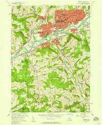 1956 Endicott1958 Print · USGSThe industrial Susquehanna Valley thrives in the mid-fifties as urban growth expands toward the southern hills. Researchers can trace the development of ENDICOTT and Endwell or locate landmarks like Harpur College, Tri-Cities Airport, and Riverside Cem.2 unique versions available
 - 1956 Map of Maine, 1958 Print
 1956 Maine1958 Print · USGSBroome County hill country is captured here during the mid-fifties, centered on the Nanticoke Creek valley settlements. Researchers can trace ancestral property near several family burial grounds like Hallenbeck Cem and Zimmer Cem or find old homesites along Death Valley Road.2 unique versions available
 - 1957 Map of Belden, 1959 Print
 1957 Belden1959 Print · USGSBroome County’s rural landscapes are captured here during the late fifties, showing a region shaped by the Delaware and Hudson railroad. Researchers can locate several family-history landmarks, including New Ohio Cem, Pratts Cem, and the village of Harpursville near the Susquehanna River.
 - 1957 Map of Afton, 1959 Print
 1957 Afton1959 Print · USGSThe Susquehanna River valley in the late fifties was a busy corridor of rail traffic and river towns. You can trace the Delaware and Hudson railroad through Nineveh Junction, locate old family plots at The Plains Cem, or find the secluded Vallonia Springs.4 unique versions available
 - 1958 Map of Binghamton
 1958 Binghamton1958 Print · USGSCentral New York in the late fifties was a network of manufacturing cities and river valleys connected by vital rail lines. Genealogists and historians can trace family roots in Oneonta, Norwich, and Cooperstown or locate long-standing farms along Schoharie Creek.
 - 1958 Map of Elmira
 1958 Elmira1958 Print · USGSThe New York Finger Lakes during the late fifties reveal a complex landscape of glacial geology and industrial growth. Researchers can trace historic transport corridors like the Erie Canal and Erie RR, or locate institutional landmarks like Cornell University.2 unique versions available
 - 1959 Map of Scranton
 1959 Scranton1959 Print · USGSThe northern coalfields and the Hudson Valley meet in this mid-century survey of the Pennsylvania and New York borderlands. Genealogists and historians can trace the intricate rail networks of the Erie Railroad and the vast waters of Lake Wallenpaupack.2 unique versions available
End of results
Showing maps 1-23 of 23
Top cities of Broome County
- Union historical maps
- Binghamton historical maps
- Vestal historical maps
- Chenango historical maps
- Fenton historical maps
- Windsor historical maps
See more
Frequently asked questions
- What are the different types of historical maps available for Broome County?
- What is the oldest map of Broome County?
- Where can I purchase historical maps of Broome County for my home or office?
- Where can I download high-res historical maps of Broome County?
- Are there historical topographic maps available for Broome County?
- Is there historical aerial imagery available for Broome County?
- Where are historical maps of Broome County sourced from?