1960s Maps of Colesville, New York
Explore 3 historic maps of Colesville from the 1960s. These maps offer a rare glimpse into what life looked like during the 1960s — showing old roads, neighborhoods, homes, and landmarks that have changed or disappeared over time.
Whether you're researching your family's past, planning a metal detecting trip, or studying how Colesville's landscape evolved across the 1960s, these high-resolution maps are a powerful tool for exploring the history of this region.
- Focus on a specific era: All maps on this page are from the 1960s, giving you a focused view of this time period.
- See what’s changed: Compare century-old streets, trails, and buildings to today's modern landscape using overlays and satellite layers.
- Research with precision: Use these maps for genealogy, historical research, land use analysis, or educational projects.
- View, download, or print: Maps are fully viewable online in high resolution, and can be downloaded or printed for your own records.
Start exploring Colesville's history through authentic maps from the 1960s. This is your window into the past.
Colesville, NY maps
(3)- 1960 Map of Chenango Forks, 1963 Print
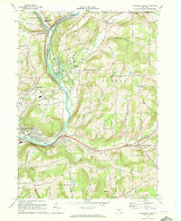
 1960 Chenango Forks1963 Print · USGSThe river valleys of Broome County come alive in this early 1960s survey of the river confluence and the growing Chenango Valley. Genealogists and local historians can trace the foundations of Chenango Forks, the grounds of Chenango Valley State Park, and rural landmarks like Toombs Cem.
 - 1963 Map of Binghamton
 1963 Binghamton1963 Print · USGSThe Southern Tier and Catskill peaks are shown in the early sixties as new reservoirs reshaped the valleys. Trace historic rail corridors like the Erie Lackawanna RR and explore lakeside settlements such as Cooperstown and Oneonta.
 - 1968 Map of Chenango Forks, 1972 Print
 1968 Chenango Forks1972 Print · USGSBroome County at the end of the sixties reveals a landscape shaped by river confluences and the expansion of the regional rail network. Genealogists and local historians can trace family markers at Toombs Cem, explore the early footprint of Port Crane, and locate the Chenango Bridge Landing Field.2 unique versions available
End of results
Showing maps 1-3 of 3
Top cities near Colesville
- Binghamton historical maps
- Chenango historical maps
- Fenton historical maps
- Windsor historical maps
- Kirkwood historical maps
- Greene historical maps
See more
Top neighborhoods of Colesville
- Tunnel historical maps
- Belden historical maps
- West Colesville historical maps
- New Ohio historical maps
- North Colesville historical maps
- Sanitaria Springs historical maps
See more
Frequently asked questions
- What are the different types of historical maps available for Colesville?
- What is the oldest map of Colesville?
- Where can I purchase historical maps of Colesville for my home or office?
- Where can I download high-res historical maps of Colesville?
- Are there historical topographic maps available for Colesville?
- Is there historical aerial imagery available for Colesville?
- Where are historical maps of Colesville sourced from?