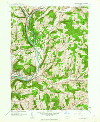
1960 Map of Chenango Forks
USGS Topo · Published 1963About this map
The confluence of the Otioughnioga River and the Chenango River serves as the focal point for this Broome County landscape during the early 1960s. The settlement at Chenango Forks marks this northern junction, where the Erie-Lackawanna railroad follows the western riverbank. The river corridor transitions from the agricultural valley into the recreation-focused Chenango Valley State Park, which includes Lily Lake, Chenango Lake, and the Chenango Golf Course.
Find a feature on this map
79 named features on this map. Tap any name to fly to it.
Don’t see what you’re looking for? This feature index may not catch every label — zoom into the map to look around manually.
Map Details
Editions of this 1960 Chenango Forks Map
This is the sole edition of this map. No revisions or reprints were ever made.
Other maps of this area

1902 · Coventry
USGS Topo · 1:62,500

1904 · Binghamton
USGS Topo · 1:62,500

1904 · Greene
USGS Topo · 1:62,500

1904 · Oxford
USGS Topo · 1:62,500

1905 · Nineveh
USGS Topo · 1:62,500

1934 · Castle Creek
USGS Topo · 1:24,000

1935 · Binghamton West
USGS Topo · 1:24,000

1935 · Chenango Forks
USGS Topo · 1:24,000

1937 · Binghamton East
USGS Topo · 1:24,000

1942 · Binghamton West
USGS Topo · 1:31,680