1940s Maps of Fenton, New York
Explore 3 historic maps of Fenton from the 1940s. These maps offer a rare glimpse into what life looked like during the 1940s — showing old roads, neighborhoods, homes, and landmarks that have changed or disappeared over time.
Whether you're researching your family's past, planning a metal detecting trip, or studying how Fenton's landscape evolved across the 1940s, these high-resolution maps are a powerful tool for exploring the history of this region.
- Focus on a specific era: All maps on this page are from the 1940s, giving you a focused view of this time period.
- See what’s changed: Compare century-old streets, trails, and buildings to today's modern landscape using overlays and satellite layers.
- Research with precision: Use these maps for genealogy, historical research, land use analysis, or educational projects.
- View, download, or print: Maps are fully viewable online in high resolution, and can be downloaded or printed for your own records.
Start exploring Fenton's history through authentic maps from the 1940s. This is your window into the past.
Fenton, NY maps
(3)- 1942 Map of Castle Creek
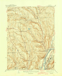 1942 Castle Creek1942 Print · USGSBroome County at the start of the 1940s reveals a region balancing river-valley industry with upland rural life. Genealogists can trace family roots through landmarks like the Camp Meeting Grounds, the Polish Cem, and schools like Finch Hollow Sch.3 unique versions available
 - 1942 Map of Chenango Forks
 1942 Chenango Forks1942 Print · USGSUpper Broome County in the years before the war shows a landscape shaped by river junctions and burgeoning state park development. Local historians can trace early school districts and railroad routes through Chenango Forks, Sanitaria Springs, and the CCC Camp at Chenango Valley State Park.3 unique versions available
 - 1948 Map of Binghamton, 1980 Print
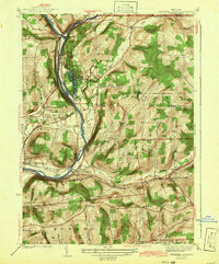
 1948 Binghamton1980 Print · USGSCentral New York and the Southern Tier thrive in the late 1940s as a hub of rail traffic and mountain industry. Researchers can trace historic transit lines like the Erie Railroad through Binghamton or find old valley settlements near Oneonta and Delhi.
End of results
Showing maps 1-3 of 3
Top cities near Fenton
- Union historical maps
- Binghamton historical maps
- Vestal historical maps
- Johnson City historical maps
- Endicott historical maps
- Endwell historical maps
See more
Top neighborhoods of Fenton
- North Fenton historical maps
- Pleasant Hill historical maps
- Port Crane historical maps
- Quinneville historical maps
- Wyman Corner historical maps
Frequently asked questions
- What are the different types of historical maps available for Fenton?
- What is the oldest map of Fenton?
- Where can I purchase historical maps of Fenton for my home or office?
- Where can I download high-res historical maps of Fenton?
- Are there historical topographic maps available for Fenton?
- Is there historical aerial imagery available for Fenton?
- Where are historical maps of Fenton sourced from?