1960s Maps of Sanford, New York
Explore 9 historic maps of Sanford from the 1960s. These maps offer a rare glimpse into what life looked like during the 1960s — showing old roads, neighborhoods, homes, and landmarks that have changed or disappeared over time.
Whether you're researching your family's past, planning a metal detecting trip, or studying how Sanford's landscape evolved across the 1960s, these high-resolution maps are a powerful tool for exploring the history of this region.
- Focus on a specific era: All maps on this page are from the 1960s, giving you a focused view of this time period.
- See what’s changed: Compare century-old streets, trails, and buildings to today's modern landscape using overlays and satellite layers.
- Research with precision: Use these maps for genealogy, historical research, land use analysis, or educational projects.
- View, download, or print: Maps are fully viewable online in high resolution, and can be downloaded or printed for your own records.
Start exploring Sanford's history through authentic maps from the 1960s. This is your window into the past.
Sanford, NY maps
(9)- 1962 Map of Scranton, 1977 Print
 1962 Scranton1977 Print · USGSThe industrial heart of eastern Pennsylvania and the New York Catskills are captured here in the early sixties. Genealogists and historians can trace the dense valley settlements from Scranton to Wilkes-Barre and the rail lines of the Erie Lackawanna Railroad.2 unique versions available
 - 1963 Map of Binghamton
 1963 Binghamton1963 Print · USGSThe Southern Tier and Catskill peaks are shown in the early sixties as new reservoirs reshaped the valleys. Trace historic rail corridors like the Erie Lackawanna RR and explore lakeside settlements such as Cooperstown and Oneonta.
 - 1965 Map of Scranton
 1965 Scranton1965 Print · USGSThe tri-state highlands of Pennsylvania, New York, and New Jersey come alive in the mid-sixties as industry and recreation converge. Trace the intricate rail lines of the Erie Lackawanna RR or locate landmarks like the U S Military Academy.2 unique versions available
 - 1965 Map of Hancock, 1967 Print
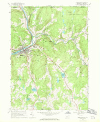
 1965 Hancock1967 Print · USGSThe convergence of the Delaware River branches defines this border region in the mid-1960s, where rail and water transport shaped local growth. Researchers can trace family roots at Kingsbury Hill Cem or explore the industrial footprint of Cadosia and the Erie-Lackawanna Railroad.3 unique versions available
 - 1965 Map of North Sanford, 1967 Print
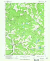
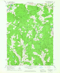 1965 North Sanford1967 Print · USGSSettled valleys meet state-managed timberlands in this mid-sixties survey of the border between Broome, Chenango, and Delaware counties. Researchers can trace family sites at China and Arctic or locate burial grounds like Beech Hill Cem and Melondy Hill Cem.2 unique versions available
 - 1965 Map of Cannonsville Reservoir, 1967 Print
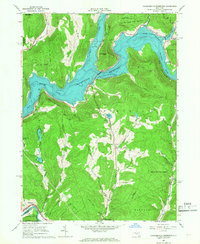 1965 Cannonsville Reservoir1967 Print · USGSThe West Branch Delaware River valley appears in the mid-1960s as the massive Cannonsville Reservoir transforms the landscape. Trace the local rail history along the Erie-Lackawanna RR or locate rural landmarks like Kelsey and the Kingswood Camp.3 unique versions available
 - 1965 Map of Deposit, 1967 Print
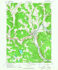 1965 Deposit1967 Print · USGSThe village of Deposit and its surrounding river valleys are captured here in the mid-sixties, shortly after the completion of the Cannonsville Dam. Genealogists and historians can trace the Erie Lackawanna Railroad and find local landmarks like Pine Grove Cem and Oquaga Lake.2 unique versions available
 - 1968 Map of Susquehanna, 1970 Print
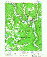
 1968 Susquehanna1970 Print · USGSSusquehanna and Oakland are shown at a peak of rail and quarry activity in the late 1960s. Genealogists can locate family landmarks like St Johns Cem, North Jackson Cem, and the Susquehanna Consolidated Sch.4 unique versions available
 - 1968 Map of Starrucca, 1971 Print
 1968 Starrucca1971 Print · USGSStarrucca and the surrounding Wayne County highlands are captured here in the late sixties as a busy crossroads of rail and ridge-top farming. Genealogists and local historians can trace family roots through Scott Center, Shehawken, and St Pauls Ch.3 unique versions available
End of results
Showing maps 1-9 of 9
Top cities near Sanford
- Windsor historical maps
- Sidney historical maps
- Greene historical maps
- Walton historical maps
- Colesville historical maps
- Unadilla historical maps
See more
Top neighborhoods of Sanford
- Danville historical maps
- McClure historical maps
- Gulf Summit historical maps
- North Sanford historical maps
- Howes historical maps
Frequently asked questions
- What are the different types of historical maps available for Sanford?
- What is the oldest map of Sanford?
- Where can I purchase historical maps of Sanford for my home or office?
- Where can I download high-res historical maps of Sanford?
- Are there historical topographic maps available for Sanford?
- Is there historical aerial imagery available for Sanford?
- Where are historical maps of Sanford sourced from?