1940s Maps of Humphrey, New York
Explore 4 historic maps of Humphrey from the 1940s. These maps offer a rare glimpse into what life looked like during the 1940s — showing old roads, neighborhoods, homes, and landmarks that have changed or disappeared over time.
Whether you're researching your family's past, planning a metal detecting trip, or studying how Humphrey's landscape evolved across the 1940s, these high-resolution maps are a powerful tool for exploring the history of this region.
- Focus on a specific era: All maps on this page are from the 1940s, giving you a focused view of this time period.
- See what’s changed: Compare century-old streets, trails, and buildings to today's modern landscape using overlays and satellite layers.
- Research with precision: Use these maps for genealogy, historical research, land use analysis, or educational projects.
- View, download, or print: Maps are fully viewable online in high resolution, and can be downloaded or printed for your own records.
Start exploring Humphrey's history through authentic maps from the 1940s. This is your window into the past.
Humphrey, NY maps
(4)- 1941 Map of Ellicottville
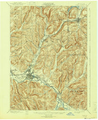
 1941 Ellicottville1941 Print · USGSCattaraugus County in the early 1940s is shown here as a landscape of rural school districts and rail-side villages. Researchers can trace the Baltimore and Ohio tracks through Riceville Sta or locate family sites near Dutch Hill Church and Fancy Tract.
 - 1942 Map of Franklinville
 1942 Franklinville1942 Print · USGSCattaraugus County during the early war years remains a land of small schoolhouses and essential rail junctions. Trace the family roots of rural New York through local landmarks like Siloam Church, County Line Cem, and the unique Checkered School.
 - 1943 Map of Olean
 1943 Olean1943 Print · USGSCattaraugus County in the late nineteenth century was a corridor of burgeoning rail and industry along the Allegheny. Researchers can trace the path of the Penna. R.R. through old settlements like Hinsdale and Westons Mills, or locate early landmarks like Rock City.
 - 1943 Map of Salamanca
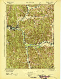 1943 Salamanca1943 Print · USGSCattaraugus County during the early 1940s reveals a landscape defined by the intersection of the Allegheny River and major rail lines. Genealogists and rail historians can trace the paths of the Erie and Baltimore and Ohio railroads through Salamanca and Killbuck.
End of results
Showing maps 1-4 of 4
Top cities near Humphrey
- Olean historical maps
- Allegany historical maps
- Salamanca historical maps
- Portville historical maps
- Cuba historical maps
- Franklinville historical maps
See more
Top neighborhoods of Humphrey
Frequently asked questions
- What are the different types of historical maps available for Humphrey?
- What is the oldest map of Humphrey?
- Where can I purchase historical maps of Humphrey for my home or office?
- Where can I download high-res historical maps of Humphrey?
- Are there historical topographic maps available for Humphrey?
- Is there historical aerial imagery available for Humphrey?
- Where are historical maps of Humphrey sourced from?