1900-1909 Maps of Sempronius, New York
Explore 2 historic maps of Sempronius from 1900-1909. These maps offer a rare glimpse into what life looked like during the 1900s — showing old roads, neighborhoods, homes, and landmarks that have changed or disappeared over time.
Whether you're researching your family's past, planning a metal detecting trip, or studying how Sempronius's landscape evolved across the 1900s, these high-resolution maps are a powerful tool for exploring the history of this region.
- Focus on a specific era: All maps on this page are from the 1900s, giving you a focused view of this time period.
- See what’s changed: Compare century-old streets, trails, and buildings to today's modern landscape using overlays and satellite layers.
- Research with precision: Use these maps for genealogy, historical research, land use analysis, or educational projects.
- View, download, or print: Maps are fully viewable online in high resolution, and can be downloaded or printed for your own records.
Start exploring Sempronius's history through authentic maps from the 1900s. This is your window into the past.
Sempronius, NY maps
(2)- 1902 Map of Skaneateles
 1902 Skaneateles1902 Print · USGSOnondaga and Cayuga counties come alive in the Victorian era as a network of steamboats and short-line railroads connects lakeside hamlets. Trace ancestral roots and old transport routes through Mottville, the Skaneateles RR, and remote landings like Gregory Ldg.9 unique versions available
 - 1902 Map of Moravia
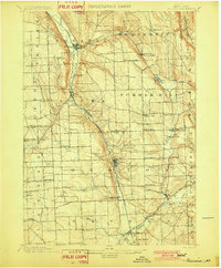 1902 Moravia1902 Print · USGSThe rural landscapes of Cayuga and Tompkins counties are captured here at the start of the twentieth century, when small hamlets thrived along the rail lines. Genealogists can trace family names and vanished post offices at Goosetree, Morse Mill, and Grotto.7 unique versions available
End of results
Showing maps 1-2 of 2
Top cities near Sempronius
- Auburn historical maps
- Onondaga historical maps
- Cortland historical maps
- Dryden historical maps
- Lansing historical maps
- Cortlandville historical maps
See more
Top neighborhoods of Sempronius
Frequently asked questions
- What are the different types of historical maps available for Sempronius?
- What is the oldest map of Sempronius?
- Where can I purchase historical maps of Sempronius for my home or office?
- Where can I download high-res historical maps of Sempronius?
- Are there historical topographic maps available for Sempronius?
- Is there historical aerial imagery available for Sempronius?
- Where are historical maps of Sempronius sourced from?