1940s Maps of Sterling, New York
Explore 5 historic maps of Sterling from the 1940s. These maps offer a rare glimpse into what life looked like during the 1940s — showing old roads, neighborhoods, homes, and landmarks that have changed or disappeared over time.
Whether you're researching your family's past, planning a metal detecting trip, or studying how Sterling's landscape evolved across the 1940s, these high-resolution maps are a powerful tool for exploring the history of this region.
- Focus on a specific era: All maps on this page are from the 1940s, giving you a focused view of this time period.
- See what’s changed: Compare century-old streets, trails, and buildings to today's modern landscape using overlays and satellite layers.
- Research with precision: Use these maps for genealogy, historical research, land use analysis, or educational projects.
- View, download, or print: Maps are fully viewable online in high resolution, and can be downloaded or printed for your own records.
Start exploring Sterling's history through authentic maps from the 1940s. This is your window into the past.
Sterling, NY maps
(5)- 1943 Map of Oswego West
 1943 Oswego West1943 Print · USGSOswego and its harbor front on Lake Ontario during the early years of the war, showing a landscape defined by schools, chapels, and the historic Fort Ontario. Genealogists can trace early homesteads and communities near Fruit Valley, Irish Settlement Cem, and School No 10.
 - 1943 Map of Hannibal
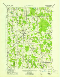 1943 Hannibal1943 Print · USGSOswego and Cayuga counties are shown here during the war years, when the landscape was a dense network of family farms and rural school districts. Genealogists can trace family footprints through numerous numbered schools and local landmarks like Bethel Cem, Martville, and the Lehigh Valley railroad line.2 unique versions available
 - 1943 Map of Fair Haven
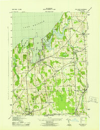 1943 Fair Haven1943 Print · USGSThe Lake Ontario shoreline in Cayuga and Wayne Counties during the mid-1940s reveals a landscape of bays, orchards, and rural school districts. Genealogists can trace family names at Springbrook Cem or locate old rail stops at Sterling Junction and Crocketts.2 unique versions available
 - 1943 Map of Red Creek
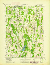 1943 Red Creek1943 Print · USGSUpper New York state during the early 1940s shows a landscape of small farming hamlets and rural school districts along the Wayne and Cayuga county line. Researchers can trace historic cemeteries like French Cem, early landmarks like the Airport, and old district schoolhouses.
 - 1943 Map of West Ninemile Point
 1943 West Ninemile Point1943 Print · USGSThe Cayuga County shoreline along Lake Ontario is captured here during the early years of the 1940s. Genealogists and local historians can trace the rural landscape of Sterling, finding landmarks like School No 12 and Ninemile Cr.
End of results
Showing maps 1-5 of 5
Top cities near Sterling
- Lysander historical maps
- Oswego historical maps
- Van Buren historical maps
- Fulton historical maps
- Oswego historical maps
- Scriba historical maps
See more
Top neighborhoods of Sterling
- Martville historical maps
- Fintches Corners historical maps
- Moon Beach historical maps
- North Victory historical maps
- Sterling Valley historical maps
- Crocketts historical maps
See more
Frequently asked questions
- What are the different types of historical maps available for Sterling?
- What is the oldest map of Sterling?
- Where can I purchase historical maps of Sterling for my home or office?
- Where can I download high-res historical maps of Sterling?
- Are there historical topographic maps available for Sterling?
- Is there historical aerial imagery available for Sterling?
- Where are historical maps of Sterling sourced from?